
Things to do in Basu
Explore top experiences
Top 10 attractions in Basu


Ranwu Lake
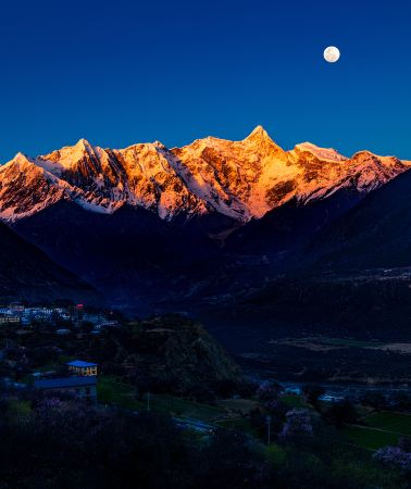
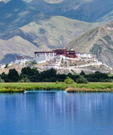
Ranwu Lake is a barrier lake in the headwaters of the Parlung Zangbo River, a tributary of the Yarlung Zangbo River, formed by landslides and debris flows blocking the river channel. The lake sits at an altitude of over 3,800m, and the narrow lake body stretches for over 20 km, consisting of three connected lakes—Yangcuo, Bangcuo, and Leng'anjia Bu—forming a chain. It is no more than 1–2 km wide at its widest point, resembling a string of pearls laid beneath the snow-capped mountains. Its end is adjacent to the Laigu Glacier group, and glacial meltwater continuously flows into the lake, providing a constant supply. The lakeshore is covered with vast meadows, the pebble beaches along the shore are colorful, and white waterfowl can often be seen swimming in the shallows. Each season here has its own highlights: in spring, tree shadows sway on the lake surface; in summer, the meadows turn green; in autumn, the forests are dyed golden; in winter, mist fills the air and snow-capped peaks stretch endlessly, and the lake water also shifts between azure blue and greenish-blue depending on the season and lighting.Basu · 69.2 km from downtown

Laigu Glacier
Many glaciers surrounding Laigu Village have formed many ice lakes in front of the village. Due to the different geology and soil composition of different glaciers, each ice lake will reflect different colors. There is a large ice lake floating on the ice lake. Big and small icebergs. Between the end of the glacier and the glacial lake, the broken glacier reveals a layer of blue ice tens of meters high. In Laigu Village, you can see Meixi Glacier, Yalong Glacier, Ruojiao Glacier, Dongga Glacier, Xiongjia Glacier and Niuma Glacier. Because all these glaciers surround Laigu Village, they are collectively called Laigu Glaciers ( Note: Due to the changing seasons of glaciers, the viewing period of each glacier is different, and the scenery seen at different times is different.) Among them, the Yalong Glacier, which is 12 kilometers long at the eastern end of Gangrigabu Mountain, is more majestic. It is more than 6,000 meters above sea level. The main peak extends to the edge of Laigu Village at an altitude of about 4,000 meters. The simple village road along the Ranwu Lake, even if you have reached the ancient village, the Laigu Village with more than 70 households still maintains the original Tibetan village style of half farming and half pastoralism. The houses in the village are relatively scattered, subdivided into several smaller villages and settlements such as Shatuna, Lanage, Qu'e, and Ranmu. The distance between the villages is two to three kilometers, and there are fields between the small villages. ridge.Basu · 86 km from downtown

Zig-Zag Mountain Road With 72 Turns
The 72nd turn of the Nujiang River is located in the Basu County in the Qamdo region, and is located between the Changdu Bangda and Basu on the southern Sichuan-Tibet line, also known as "the 99th turn of the Sichuan-Tibet". The 72nd turn of the Nujiang River is not a scenic spot, but almost all passers-by will stop for a while and enjoy the surrounding mountains when they reach the commanding heights of the road. The Nujiang River 72 turns westward from Bangda, climbs Yela Mountain with an altitude of about 4,658 meters, and then circles down to the Nujiang Canyon with an altitude of about 3,100 meters. The relative height difference is nearly 1,500 meters, and the winding road is about 12 kilometers. As the only way to go through the south Sichuan-Tibet line, the road is narrow and the slope is steep. For many riders or riders, it is precisely because of its danger that it is more challenging. Pedestrians passing by this road every year are full of sigh.Basu · 37 km from downtown

Rawu Town
Rawu Town is a town under the jurisdiction of Baxoi County, Qamdo City, Tibet Autonomous Region, and administers 12 village committees:Waba Village,Ranwu Village, Ranna Village, Zhongba Village, Kangsha Village, Laigu Village, Kadui Village, Maiba Village, Yaka Village, Ari Village, Yaze Village, and Daba Village. It is located in the western part of Baxoi County, Qamdo City, Tibet Autonomous Region, approx. 90 km from the county seat. Major tourist attractions include Ranwu Lake, Laigu Glacier, andDemla Mountain Passon the Rancha Highway. Ranwu Lake is a beautiful sight in Ranwu, a plateau lake nestled among high mountains, with an elevation of over 3,800m. It is located approx. 89 km southwest of the Baxoi county seat, and the Sichuan-Tibet Highway passes by its shore. It is the source of theParlung Tsangpo River, and the climate here is humid and rainy in summer. Ranwu Lake provides a clean and abundant water source for Rawu Town. There are grasslands and farmland by the lake, and in the distance, you can see rolling snow-capped peaks and ancient sand willows that have grown naturally for thousands of years. It is well worth staying for a few days. From Ranwu, it only takes 1 km to reach the edge of Ranwu Lake after turning onto the Rancha Highway. There are snow-capped peaks by the lake, and the scenery is beautiful.Basu · 63.3 km from downtown

Yalong Glacier
Yalong Glacier is one of the six ancient glaciers. Yalong Glacier spreads out from the main peak of Gangri Gabu Mountain at an altitude of 6,606 meters and extends to Gangri Gabu Lake at an altitude of 4,000 meters.Basu · 83.5 km from downtown

Renlongba Glacier
Located in Qamdo City, the Rinongba Glacier is a spectacular and little-known natural wonder. The glacier covers a vast area, with its tongue winding down, creating a unique snow and ice landscape. Due to its remote location, the glacier has remained in its original natural state, where visitors can experience the majesty and tranquility of nature. The terrain around the glacier is complex and varied. In addition to snow-capped peaks, there are alpine meadows and lakes dotted in between, with rich biodiversity. Hiking is the main way to explore the Rinongba Glacier, and you can enjoy the magnificent natural scenery and unique plateau ecology during the journey. As the glacier is located at a high altitude, a trip to the Rinongba Glacier requires adequate preparation, including acclimatization to the plateau climate and carrying the necessary mountaineering equipment. Although the journey may be challenging, the glacier's magnificent scenery and pure natural environment are undoubtedly worth the trip.Basu · 90.1 km from downtown

Duola Sacred Mountain
The scale of Mount Dora is not very large, and it is traditionally divided into an outer ring, a middle ring and an inner ring. It takes about 4 hours to walk around the middle circle on foot. Along the way, you can see the sky burial platform and various stone carving arts. Climbing to the main peak, you can get a bird's-eye view of the entire Dora Mountain. It takes no more than 2 hours to make a circle from the inner circle. This is the core part of Mount Dora, and it is also the main visiting point. On the way, you can worship and appreciate various Buddha statues, pagodas, six-character mantras and Tibetan Prayer. The mystery of Mount Dora lies in the fact that the limestone all over the mountain is full of Buddha statues and six-character mantras. Due to the age, coupled with years of wind and rain, the weathering phenomenon is extremely serious, so it has long lost its artificially carved imprints, which makes many people believe that these Buddha statues and six-character mantras are formed naturally.Basu · 3.3 km from downtown

Yela Mountain
Basu · 39.4 km from downtown

Nujiang Bridge
Basu · 27.7 km from downtown

Bangda Grassland
Located in the high mountains and deep valleys of the Sanjiang River Basin in the Qamdo region, the Bangda Grassland is an alpine grassland with gentle terrain and lush water plants. The upper reaches of Yuqu, a tributary of the Nujiang River, meanders through it. On the broad low-wet beaches on both sides of the river, there are dense and low meadow plants such as wormwood and serratia. , and occasionally there will be some Tibetan gazelles in the meantime. This is a relatively fine grassland in Tibet. The unique and prosperous grassland environment has also made Bangda the main producing area of many medicinal plants, such as Fritillaria, ginseng fruit, rhubarb, large-leaf chinensis and rhodiola, among which the well-known is Cordyceps sinensis, which is very precious. It used to be the place where the famous "Tea-Horse Road" must pass in the past. Now it has opened up Sichuan-Tibet, Sichuan-Yunnan and other highways connecting Tibet and neighboring provinces such as Sichuan, Yunnan and Qinghai. In 1995, a state was established on this plateau. It reached the airport and opened up the air route from Qamdo to Chengdu.Basu · 56.4 km from downtown
Experiences you can't miss in Basu
Featured Travel photography in Basu
View all Travel photography![Bome travel photo shoot[Family Portraits, Parent-Child Photos, Wedding Photography, Aerial Shots, Street Photography, Candid Shots, Photo Sessions, Wedding & Portrait Photography, Videography, Translation Services]](https://ak-d.tripcdn.com/images/0352012000o3mzc3iB2B9_C_568_320.jpg?_fr=wc)
![Qamdo Trip Moments[Family Portraits, Parent-Child Photos, Wedding Photography, Aerial Shots, Street Photography, Candid Shots, Photo Sessions, Wedding & Portrait Photography, Videography, Translation Services]](https://ak-d.tripcdn.com/images/0351s12000o809tlo02E3_C_568_320.jpg?_fr=wc)
![Travel photo shoot in Zayu[Snow Mountain Secret Photography: Aerial, Follow, and Editing Services with 1-on-1 Multilingual Photographer]](https://ak-d.tripcdn.com/images/0356j12000o6nkv7z47A4_C_568_320.jpg?_fr=wc)
Instant confirmation
Book now for today
From€29.91
![Qamdo Travel Photography[Driver and guide + travel photography + wedding photos, aerial photography, micro-film + makeup and clothing + itinerary customization ]](https://ak-d.tripcdn.com/images/0356x12000o80bt1wC8C8_C_568_320.jpg?_fr=wc)
5.0/5
· 1 reviewInstant confirmation
Book now for today
From€14.96
![Zhag'yab Travel Photography[Enda Hot Spring Waterfall photography and aerial videography + multilingual local photographer]](https://ak-d.tripcdn.com/images/0355g12000o6l9t5nA672_C_568_320.jpg?_fr=wc)
Instant confirmation
Book now for today
From€29.91
![Trip Moments in Zogang County[Promotional videos, microfilms, documentaries/wedding photography activity shooting/commercial photography and videography/all raw footage included]](https://ak-d.tripcdn.com/images/0350j12000qdwxfd470D7_C_568_320.jpg?_fr=wc)
From€358.89
Featured SIM card in Basu
View all SIM card
4.6/5
· 69.6k reviews· 2mil bookedFree cancellation
Book now for today
Fast-selling Wi-Fi & SIM cards
50% off
Limited-time sale
From€0.08€0.16

4.6/5
· 9.6k reviews· 233.5k bookedFree cancellation
Book now for today
19.272k bookings in 7 days
53% off
Limited-time sale
From€0.07€0.15

4.6/5
· 31.7k reviews· 936.7k bookedFree cancellation
Book now for today
Fast-selling Wi-Fi & SIM cards
50% off
Limited-time sale
From€0.08€0.16

4.6/5
· 23.6k reviews· 659.5k bookedFree cancellation
Book now for today
Fast-selling Wi-Fi & SIM cards
50% off
Limited-time sale
From€0.08€0.16

4.6/5
· 6.5k reviews· 189.6k bookedFree cancellation
Book now for today
Fast-selling Wi-Fi & SIM cards
53% off
Limited-time sale
From€0.07€0.15

4.6/5
· 9.1k reviews· 237.1k bookedFree cancellation
Book now for today
Similar travelers pick
53% off
Limited-time sale
From€0.07€0.15

4.6/5
· 2.3k reviews· 57.4k bookedFree cancellation
Book now for today
90.8% of travelers recommend
53% off
Limited-time sale
From€0.07€0.15

4.7/5
· 5.3k reviews· 136.1k bookedFree cancellation
Book now for today
92.6% of travelers recommend
53% off
Limited-time sale
From€0.07€0.15
Free things to do in Basu
Ranwu Lake
Basu · 69.2 km from downtownLaigu Glacier
Basu · 86 km from downtownZig-Zag Mountain Road With 72 Turns
Basu · 37 km from downtownRawu Town
Basu · 63.3 km from downtownYalong Glacier
Basu · 83.5 km from downtownRenlongba Glacier
Basu · 90.1 km from downtownDuola Sacred Mountain
Basu · 3.3 km from downtownYela Mountain
Basu · 39.4 km from downtownNujiang Bridge
Basu · 27.7 km from downtownBangda Grassland
Basu · 56.4 km from downtown
More ways to travel from Basu
Group Tours in Basu
View More Group Tours in Basu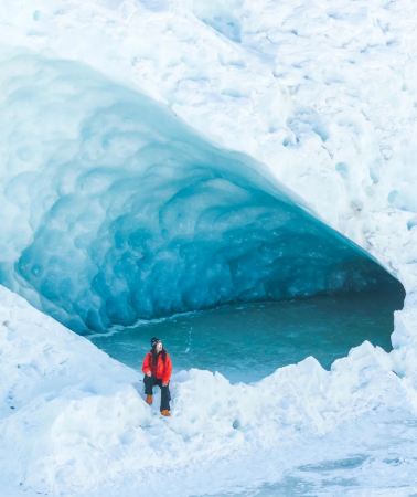


What travelers say about Basu

tokiiiiJuly 1, 2025
5.0
Tibet! I would like to do it thousands of times!
To see the most beautiful scenery of Ranwu Lake, you must go there in early spring in Tibet, around mid-to-late April, when the frozen lake surface has just melted, the azure blue water is exposed above the ice, and the snow-capped mountains are reflected in the water. After seeing it, you can't help but sigh: It's so beautiful!
Ranwu Lake

M49***48October 9, 2025
5.0
Laigu Glacier, one of the world's three largest glaciers, is located in Ranwu Town, Basu County, Qamdo Prefecture, Tibet. It offers a glimpse into a dreamlike wonderland of 10,000-year-old blue ice. The crystal-clear ice, snow-capped mountains, and glacial lakes create a breathtaking spectacle, akin to stepping back into the Ice Age and experiencing the power of nature. The best viewing period is from December to February, when the ice is solid and at its largest. At an altitude of approximately 4,200 meters, be prepared for cold and altitude sickness, and crampons are recommended for safe trekking.
Laigu Glacier

倩ang🍓🍉🍑🍒August 25, 2025
5.0
The 72 bends of the Nujiang River are a "road miracle" deep within the Hengduan Mountains. In just 12 kilometers, the altitude plummets 1,500 meters, and the 72 bends wind through the mountains like a silver chain, each one a breathtaking spectacle.
Driving along this route, you'll sometimes plummet to the valley floor, watching the Nujiang River surge like emerald jade; sometimes, you'll circle the mountaintops, gazing at a sea of clouds over snow-capped peaks. On clear days, sunlight slices through the mist, casting a shimmering shadow over the bends. On rainy days, clouds and mist stream past the car windows, and the wheels roll over not only the road but also the vastness of the world.
This is a testing ground for the brave and a collector of beautiful scenery. Every turn is a soulful encounter with snow-capped mountains, canyons, and rivers, making every second of the drive a breathtaking experience etched into the memory.
Zig-Zag Mountain Road With 72 Turns

M31***54June 23, 2020
5.0
Ranwu, a place you must have fun in Tibet, a place that must be highly recommended
[Scenery] 👿👿👿👿👿👿👿👿👿👿👿👿👿👿👿👿👿👿👿👿👿 Paradise on earth
Rawu Town

netcatSeptember 21, 2020
4.0
"Renlongba Glacier", commonly known as "Renlongba Glacier", is located in "Rilungba" on the high mountains at the junction of Ranwudun, Basu County, Qamdo City, and Zayu County, Nyingchi Prefecture, Tibet. The end of the glacier tongue is 4560m above sea level. It is several kilometers long, with towering snow-capped mountains towering behind it. It is one of the few mid- to low-latitude marine modern mountain glaciers on earth.
Renlongba Glacier

enjoyzentMay 21, 2021
4.0
The Dora Mountain is located in Basu County, Qamdo City, Tibet. The hiking route is divided into the outer circle, the middle circle, and the inner circle. It takes about 4 hours to walk around the middle circle. Along the way, you can see the sky burial platform and various stone carvings. Climbing to the main peak, you can have a bird's eye view of the entire Dora Mountain. On the way, there are various Buddha statues, pagodas, six-syllable mantras, and Tibetan prayers, mainly Guru Padmasambhava.
Duola Sacred Mountain

gz当地向导伊妹儿March 27, 2021
5.0
We drove to Yela Mountain at an altitude of 4,658 meters. I had a little altitude sickness, but it felt good. The scenery was pleasant, the temperature was good, the sun was shining, it was interesting, and the price-performance ratio was very high. It was a good choice and a good experience.
Yela Mountain

binger1031July 22, 2022
5.0
1. The Nujiang Bridge and Tiger Mouth section are often subject to traffic control, especially during the rainy season. The hotel owner said that as long as it rains, landslides are very likely to occur due to geological reasons, which is very dangerous. It is usually closed at 8 pm and will be opened the next day depending on the situation. When it is sunny, even steel cannot pry the cliff.
2. I originally liked such rocks, the exposed rocks are crumbling, revealing a sense of desolation. But... the traffic control was blocked for several hours. I saw a car being hit by falling rocks on the way and realized that this is the other side of 318, or the more real side. The Nujiang Bridge is almost a bridge built in the gap of the Nujiang Gorge. It is a miracle in the history of Chinese roads and is called the throat of the Sichuan-Tibet Highway. On one side, the river water hits the shore and sighs at the magic of nature, and on the other side, the cliffs cut by knives and axes make people miss the era of "letting the mountains bow their heads and let the rivers give way". The strong wind in the canyon cannot take away the great achievements of the ancestors, the surging river water cannot flow away the great achievements of the ancestors, and the dust of the years cannot forget the tragic stories of the ancestors. This old bridge, which solidified the blood and lives of our ancestors, has been replaced by a new bridge, but that spirit, like Highway 318, will always exist on the vast plateau. Along the way, what impressed me most was not only how shocking the scenery was, but also how difficult it was to build this highway.
Nujiang Bridge

非凡轶生September 6, 2023
5.0
The Bonda Grassland is located in the Qamdo area of the Tibet Autonomous Region. It is a high-altitude grassland with a wide and gentle terrain and abundant water and grass. The Bonda Grassland is more than 130 kilometers away from Basu County.
Bangda Grassland


