OverviewBookNearbyReviewsWin PrizesRecommended
Share to
Dulongjiang Canyon
獨龍江峽谷4.1
29 Reviews
Open year round, 24/7
Recommended sightseeing time:1 hour
Address:
In Gongshan Dulong Nu Autonomous County, Nujiang Dong Autonomous PrefectureMap
What travelers say:
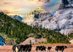
Dulongjiang "Little Switzerland", from the primitive society into the modern civilized society of the Dulong people, until 1923 to take their first photo. Now there are beautiful cabins and 5G signals, it is really amazing my country! This is Longyuan Village, Dulongjiang Township. Many nearby villages are as beautiful as here. Each village is a two-story building. The design shape is integrated into the elements and culture of their respective ethnic groups. Under the setting off of blue sky and white clouds, green waters and green mountains, It's like a small village in the Alps.
MoreSaved by 1
Dulongjiang Canyon Highlights: Must-See Features and Attractions
Some information may have been translated by Google Translate
The tour guide's road into the Dulong River is a township-level road that has just been built, and the road ends when it reaches the village. If you want to really enter the settlement of the Dulong people, you still need to walk for a long time, and they live relatively scattered. In the process of hiking the Dulong River, walking more than 15 kilometers every day is a big test for physical strength and perseverance. You need to think carefully before traveling. Main routes of the Dulong River section: Suspension bridge (right bank of the river) → Tiemu Bridge → Maku Hymn → Downhill → Qinlangdang → Jiezhuan → Climbing to the top (turn right from Yakou fork) → Maku → Suspension Bridge → Tengmei Bridge → Kong when. According to the information provided by the Gongshan Tourism Bureau: Gongshan - Qiqi 17 kilometers, Qiqi - Dongshaofang 13 kilometers, Dongshaofang - Bapo 30 kilometers, Bapo - Maku 22 kilometers, Maku - The waterfall is 8 kilometers long, Bapo-Kongdang is 18 kilometers, and the whole journey is 138 kilometers. Introduction This is a remote and mysterious canyon, located in the Nujiang Lisu Autonomous Prefecture and Gongshan Dulong Nu Autonomous County in the northwest of Yunnan Province. Every November, the Dulong River Valley loses almost all contact with the outside world. The snow cover more than ten meters thick blocks all residences from the snow-capped mountains. Only when the snow and ice melts in August next year is the lively season of the river valley. The Dulong River originates from Zayu, and winds for 150 kilometers from north to south in Yunnan. The average width of the river is about 40 meters. The people of Dulong Village on both sides of the east and west banks "can hear conversations across the bank, meet and shake hands and walk for three days", which is no exaggeration. In some places, it is difficult to shake hands even after walking for ten days. Moreover, the river is fast, the reefs are sloping, and it is impossible to ferry boats, so people can only "fly" through the canyon to keep the connection between the two sides of the strait. The Dulong people can really "fly" across the canyon, and there are many ways to "fly": one is called a suspension bridge. No matter how many things the Dulong people carry, they can fly across the river from the "suspension bridge" during the day and night. Light, like walking on the ground. Another way to cross the river is to zipline. In fact, it is very dangerous to walk on the suspension bridge or zipline, but the power of survival enables the Dulong people to practice special skills, so traveling along the Dulong River, just watching the Dulong people crossing the river can make people feel great satisfaction. Special reminder: From the end of October to the end of April of the next year, the mountain is closed by heavy snow, and the rainy season from May to August is not good and dangerous. It is recommended to enter in autumn, when the climate and scenery are better. The weather in the mountains is fickle, so please be careful. Individual place names are recorded according to local pronunciation. It is recommended to have a local person familiar with the situation as a guide.
Explore near Dulongjiang Canyon: Where to Stay, Eat, and Visit
Dulongjiang Canyon Reviews: Insider Insights and Visitor Experiences
Some reviews may have been translated by Google TranslateWrite a Review
/5
Outstanding ReviewsAll (29)
Latest
With Photos (18)
Positive Reviews (23)
- 1
- 2
- 3
- 4
- 6
Frequently Asked Questions About Dulongjiang Canyon
You Might Also Like
Balagezong Grand Canyon
7.4
4.5/51698 Reviews
Save US$0.69
From US$22.78
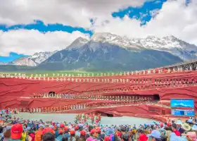
Impressions of Lijiang Performance
7.5
4.4/51192 Reviews
Save US$8.28
From US$30.37
大理環洱海旅遊觀光巴士
7.0
4.2/579 Reviews

麗江直升機空中游覽基地
4.3
5/53 Reviews
From US$273.26
Nearby Attractions
The First Bend of Nujiang River | Gongshan County | Salween River Zipline | Antarctica Lo | Gongdangshen Mountain | Dimaluocun | Baihanluo Church | 南姐洛 | Dandang Park | Sanjiang Mingzhu Square | Qiqialuo | Minzu Culture Tourism Square | Jiuzimuke Village | 石門摩巖壁刻 | Dijiacun River-crossing Cableway | Shimenguan Bas-reliefs on Precipices Carved Stone | Nujiang No.1 Knarl | Dalahe | Gema Luohe | Longwangluo | Langgeluo | Bibi Lihe | Nengzhaluo | Pulahe | Dazhiluo | Muqiaohe | Dangliu'a | Liujizhi | Teli Wanghe | Gawangluo
Popular Types of Attractions in Gongshan
Nature | Mountains | Lakes | Grasslands | Architecture & Landmarks | Historical Architectures | Featured Neighborhoods | Squares | Traditional/Cultural Experiences | Villages | Traditional Experiences | Farms | Historic Sites | Historical Sites | Ancient Villages | Ancient Towns | Religious Sites | Temples | Memorial Temples | Churches and Cathedrals | Outdoor Sports | Mountain Climbing | Hiking | Equestrian | Exhibition Centers | Museums | Fine Art Galleries | Memorial Halls | Lifestyle | Campgrounds
Popular Restaurants in Gongshan
怡峰饭店 | 火腿土锅鸡 | 原汤火锅 | 川香园餐厅 | Sanjiangyuannongjia Restaurant | 贡山阿里五精品酒店·丙中洛阿里五怒族特色餐厅 | 怒江贡山伊拉米拉云居酒店·清晏餐厅 | 丙中洛云野·见江·餐厅 | 丙中洛云野·见江·coffee 咖啡馆 | 湘怒缘主题大酒店餐饮 | 贡山秋那桶阿土家民宿 | 重庆小吃 | 永平黄焖鸡 | KUAI LE XIAO CHI | 爱上秦妈火锅店 | 独龙悦来饭店 | 清真米泽园永平清真铜瓢牛肉 | 食全食美 | 玉英农家小吃 | 神龙餐厅 | 川南四季烤鱼 | 啊怒小吃 | 阿仁农家乐 | 傈僳人家 | 丽江小吃 | Lijiangteselapaigu | 乐时聚饭店 | 贡山县米莱主题餐厅 | 茶乡缘酒家 | 仙湖饭店
Popular Destinations
Weihai Travel | Yantai Travel | Munich Travel | Subic Bay Travel | Lisbon Travel | Nanchang Travel | Fukuoka Travel | Madrid Travel | Zhoushan Travel | India Travel | Kuching Travel | Kathmandu Travel | Mohe Travel | Port Dickson Travel | Yogyakarta Travel | Pyeongtaek-si Travel | Beihai Travel | Baruaghat Travel | Snydertown Travel | Backa Travel | Poselok Tekstilshchikov Travel | Pedro Meoqui Travel | El Arrayan Travel | Bisawadi Travel | Skydra Travel | Lovell Travel | Turvelandia Travel
Recommended Attractions at Popular Destinations
Bangkok attraction near me | Tokyo attraction near me | Manila attraction near me | Hong Kong attraction near me | Seoul attraction near me | Taipei attraction near me | Los Angeles attraction near me | New York attraction near me | Shanghai attraction near me | Kuala Lumpur attraction near me | Shenzhen attraction near me | Osaka attraction near me | Singapore attraction near me | Guangzhou attraction near me | London attraction near me | San Francisco attraction near me | Beijing attraction near me | Macau attraction near me | Bali attraction near me | Paris attraction near me | Ho Chi Minh City attraction near me | Orlando attraction near me | Jakarta attraction near me | Phuket attraction near me | Chicago attraction near me | Toronto attraction near me | Istanbul attraction near me | Cebu attraction near me | Dallas attraction near me | Seattle attraction near me
Popular Trip Moments
If you come to Yunnan, you can also visit Nujiang! | Step into the Hengduan Mountains, cross the Three Rivers, and embark on a trekking journey in Bingzhongluo | The Mysterious Dulong River: Unveiling Millennia of Secrets on Foot | Gongshan Gorge Grand Hotel | Explore Bingzhongluo: Step into the mysterious natural scenery and quaint villages | Rivers, lakes, seas, and streams, mountains and rivers, intoxicate the beauty of China, beauty in Yunnan | Bingzhongluo, the treasure destination in my heart/This homestay is amazing | Bingzhongluo "Peach Blossom Island" | The newly opened Misty Village Campsite Hotel is located at the foot of the mountain | Nujiang | So beautiful it brings tears to your eyes! This aesthetic homestay in Bingzhongluo is truly sensational | The gods and humans dwell together in Bingzhongluo | Bingzhongluo is the first bend of the Nu River | Bingzhongluo Wulicun | A relaxing weekend healed by the mountains, at the Bincenluo Treasure Homestay | Bingzhongluo is a homestay! Live in the forest, live in nature! | Tibet | It's difficult to enter Tibet via Bingcha line, sharing the scenery of the junction of Yunnan and Tibet | Look, I've found the real ceiling B&B in Bingzhongluo! | In Yunnan, I stayed at the Hotel of Life! | The last small village before entering Tibet, 'Qiu Na Tong' | Bingzhongluo's Tea Horse Ancient Road light hiking | The starting point of Bingzhongluo~ Bingzhongluo Town | Dulong River 'Little Switzerland' | Yunnan Surroundings|The healing paradise hidden in the mountains and forests | Yunnan's most unmissable secret road | Travelogue of Northwestern Yunnan | Come to Bingzhongluo, Yunnan for a few days of peaceful life in a courtyard | Yunnan-Tibet Trip 23 | I don't want to check out! I want to stay in this homestay for a whole month! | Yunnan, come to Bingzhongluo for this poetic homestay in the secluded valley
More Things To Do in Gongshan
China eSIM Day Pass/data Package days selected without cards QR code | China Mainland/Hong Kong/Macau eSIM (QR Code) | China Mainland eSIM|China Mobile Unlimited 4G High Speed Data | China, Hong Kong, and Macau eSIM|Total 5GB/10GB/15GB/20GB High-speed 4G LTE Unlimited high-speed data | Mainland China eSIM |China Mobile 4G high-speed unlimited data eSIM | Asia・Australia eSIM|AIS SIM2Fly 8 days 6GB High-speed Unlimited 5G/4G Data | [China Mainland] eSIM | SIM to China | 8GB 8days 4G high speed | Mainland China + Hong Kong + Macau eSIM 4G Data Daily Plan QR Code | Trip.SIM Japan, South Korea, Macau, Taiwan and many places in Asia + Australia and New Zealand 4G travel data roaming phone network card 4 days/7 days | eSender - Mainland China eSIM daily package/traffic package, days optional. No need to get the card QR code | [China, Hong Kong and Macau] 4G network | Unlimited traffic | Self-pickup at the airport | WiFi rental, high-speed traffic, shared by multiple people, ready to use at startup, 12H standby, 24H customer service | China/Hong Kong/Macau eSIM 4G high-speed network QR code | China, Hong Kong, Macau 4G SIM Card (HK, Macau, Taiwan, China Delivery Only) | Global multi-region A series eSIM|High-speed data, travel and business Internet access, optional unlimited data, optional days, QR code | Mainland China + Hong Kong + Macau eSIM Data Plan QR Code | AIS Asia esim data package (QR code) | eSIM for China, Hong Kong and Macau. Universal for Mainland China/Hong Kong/Macau. Optional days for travel and business. QR code | China 4G SIM Card (HK, Macau, Taiwan, China Delivery Only) | Global multi-region C series eSIM|Common in 84 countries Travel and business Internet access Optional unlimited data Optional days QR code | Weixi Camping Service[Antarctic Hiking Activities] | [Hong Kong, Mainland China] 4G Internet Card | China Unicom/Hutchison | Unlimited data SIM card | Optional days | Insert the card and use | Self-pickup at Hong Kong Airport | eSender- Brunei/Indonesia/Singapore/Japan and many other countries and regions eSIM daily package/data package (QR code) | 2-Day Shangri-la Private Tour: Napa Lake, Benzilanzhen, Jinsha River, Dongzhulin Temple, Flying Temple, Meili Snow Mountain | Asia 9 Regions eSIM 4G Data Daily Plan QR Code | [Mainland China, Hong Kong and Macau] 4G Internet Card|China Unicom/Hutchison/CTM|Unlimited data SIM card|Number of optional days|Insert the card and use|Self-pickup at Hong Kong Airport | 3-Day Shangri-la Private Tour: Mingyong Glacier, Jinsha River Big Turn, Benzilan Town | Mainland China eSIM high-speed network QR code | Global eSim for 140+ countries (sent via email) by Xplori | Global (30 Countries) eSIM Data Package (QR Code) | AIS Global esim data package (QR code)
Payment Methods
Our Partners
Copyright © 2024 Trip.com Travel Singapore Pte. Ltd. All rights reserved
Site Operator: Trip.com Travel Singapore Pte. Ltd.
Site Operator: Trip.com Travel Singapore Pte. Ltd.
Dulongjiang "Little Switzerland", from the primitive society into the modern civilized society of the Dulong people, until 1923 to take their first photo. Now there are beautiful cabins and 5G signals, it is really amazing my country! This is Longyuan Village, Dulongjiang Township. Many nearby villages are as beautiful as here. Each village is a two-story building. The design shape is integrated into the elements and culture of their respective ethnic groups. Under the setting off of blue sky and white clouds, green waters and green mountains, It's like a small village in the Alps.
Dique Waterfall, before entering the Dulong family Longyuan Village, will pass through this waterfall, opposite the Dulong River, separated by the green river, very eye-catching. "A bridge, two families, a few chickens. Deep in the clouds and mist, the wind and water rise. A river, two fishing nets, Sanzhang waterfall. Winter goes to spring, flowers bloom." This is a couplet carved on the stone tablet, depicting the daily life scene of the Dulong people. The fish in Dulongjiang is very delicious, belonging to the high-altitude snow-capped cold water fish, slow growth, difficult to eat.
Dulongjiang Canyon is recognized by experts as the "Wild Plant Natural Museum", which is one of the most complete areas of primitive ecology in China. The canyon is steep, and the Gaoligong Mountain on the east bank shields the passage to the outside world. The Danzhunka on the west bank is a natural barrier on the border.
It is fully open now, no need to make an appointment, register at the entrance of the scenic spot, and get the fire prevention instructions to enter. The scenic spot integrates snow-capped mountains, forests, river flows and characteristic villages. The intersection is good, but there are many narrow bends on the road. Non-local people drive below 40 kilometers per hour, and you can stay in it for one night and play slowly.
Dulongjiang originated from the peaks of the southern peak of Boshula Mountain in Chayi County, Tibet, known as Gadaqu and Meier Dongqu. It flows through the southeast of Chayi County, Tibet, Gongshan County, Yunnan, and Kachin State, Myanmar. After entering the Yunnan Gongshan Mountains, it is called Dulongjiang. Dulongjiang is located in the westernmost river of the "three rivers", which is one of the core of the "three rivers". In addition to the Jinsha River, Lancang River and Nu River, it exists independently and is known as the "fourth river".