OverviewBookNearbyReviewsWin PrizesRecommended
Share to
Xinlu Hai
玉隆拉措風景區3.6
68 Reviews
Recommended sightseeing time:3 hour
Address:
Manigango Township, Dege County, Ganzi Tibetan Autonomous PrefectureMap
Phone0836-8223355
What travelers say:
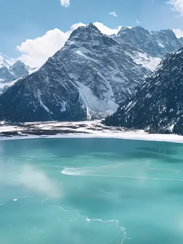
Yulong Lacuo is located in Queer Shandong Province, at an altitude of 4040 meters, formed by glacier erosion, and replenished by ice and snow melt water. Yulong Lacuo is a sudden towering glacier snow peak in the south, and the pasture of the village of Tsuo, where the grass is abundant, and the east and west sides are dense with plateau spruce and meadows. Here ecological primitive, lush vegetation, lift the eyes of snow peaks, low head wild Fang, there are wild ducks swimming fish play in the water, lama tourists wandering on the lake, a fairyland on earth, paradise.
More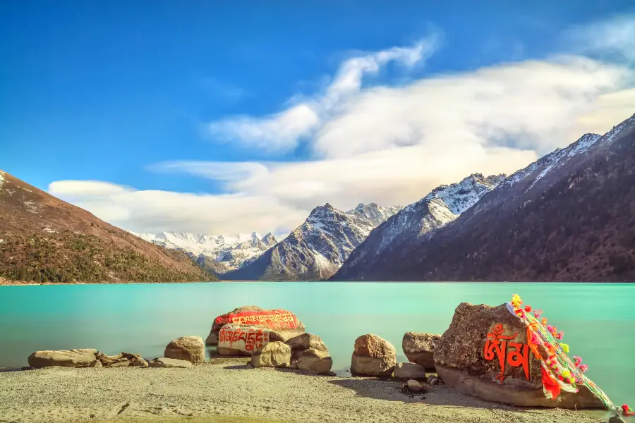
See all 10 photos
Saved by 5
Xinlu Hai Highlights: Must-See Features and Attractions
Some information may have been translated by Google Translate
Xinluhai is located at the foot of Queer Mountain in Dege County, on the side of Sichuan-Tibet Highway, and is a famous glacial lake in Ganzi Prefecture. The water source is supplied by the melting of glaciers and snow in Queer Mountain, and the stream flowing out of the tail of the lake is one of the sources of the Cuoqu River. Xinluhai is called Yulong Lacuo in Tibetan, "Jade is the heart, dragon is the tip, and Lacuo is the divine lake. Xinluhai and the surrounding ecology are primitive and complete. The large crystal glaciers run straight from the grain snow basin at an altitude of 5,000 meters. The lagoon coastal grassland is extremely spectacular. The lake is surrounded by plateau spruce, fir, cypress, rhododendron trees and meadows. The blue sky and white clouds, the snow-capped peaks, the glaciers, the green mountains, the green grass and the sparkling waves. There are rare birds on the lakeshore. Beasts haunt the lake, wild ducks are in groups, and fish are cruising. In summer and autumn, the mountains and flowers are blooming, and the flowers are in full bloom. , This lake has a large area. Under the guidance of the guide, you can go around the lake and walk a few steps, and you can hear the sound of waves and birdsong. It is a good place for meditation.
Explore near Xinlu Hai: Where to Stay, Eat, and Visit
Xinlu Hai Reviews: Insider Insights and Visitor Experiences
Some reviews may have been translated by Google TranslateWrite a Review
/5
Outstanding ReviewsAll (68)
Latest
With Photos (58)
Positive Reviews (25)
- 1
- 2
- 3
- 4
- 14
Frequently Asked Questions About Xinlu Hai
Xinlu Hai Photos: Trip Moments
 Dege Free Travel | Comprehensive Guide for Qingming Festival TourismIt's already 2024! You must visit Dege County for the Qingming Festival! 🌈🌈🌈Two-day Tour Recommendations for Dege County DAY1⃣ Cuotong Cui Lake--Yulong Laco, Muri Lake--18th Army's March into Tibet Que'er Mountain Memorial Museum--Jueri Pasture (Scenic Viewing + Horse Riding) Dining in Yaoquan Town DAY2⃣ Dege Printing House--Southern Tibetan Medicine Exhibition Hall Visit--Maisu Handicraft Park--Yutuo New Village--Gangto 18th Army's March into Tibet Crossing 🚗🚗🚗Itinerary Recommendations DAY1⃣ Cuotong Cui Lake--Yulong Laco, Muri Lake--18th Army's March into Tibet Que'er Mountain Memorial Museum--Jueri Pasture (Scenic Viewing + Horse Riding) Dining in Yaoquan Town . 🏔️ Cuotong Cui Lake Another day exploring the secret spots of Western Sichuan, a niche attraction not yet discovered by many, perfect for photography! . 🏔️ Yulong Laco A popular photo spot along the 317 self-driving route, at an altitude of over 4000 meters, every frame is beautiful. . 🏔️ 18th Army's March into Tibet Que'er Mountain Memorial Museum This is the highest altitude highway museum on the Sichuan-Tibet line, very impactful after learning about the red education, a meaningful attraction. . 🏔️ Jueri Pasture Here you can enjoy the scenery, ride horses, and leisurely appreciate the beauty of nature. DAY2⃣ Dege Printing House--Southern Tibetan Medicine Exhibition Hall--Maisu Handicraft Park--Yutuo New Village--Gangto 18th Army's March into Tibet Crossing . 🏔️ Dege Printing House Known as the 'Encyclopedia of Tibetan Culture', established in 1729! Rich in historical and cultural heritage! . 🏔️ Southern Tibetan Medicine Exhibition Hall This is part of China's intangible cultural heritage, friends interested in medicine can browse in detail here, and learn a lot. . 🏔️ Maisu Handicraft Park Located in the southeastern part of Dege County, this town park has inherited many folk handicraft cultures. If you are interested in the handicrafts of the Tibetan area, welcome to visit. . 🏔️ Yutuo New Village A village with rich folk customs, houses with ethnic characteristics are scattered in an orderly manner. . 🏔️ Gangto 18th Army's March into Tibet Crossing As the 'First Village of Tibet Liberation', it carries many red memories, very meaningful for learning. 📝📝📝Practical TIPS 🌀 Be sure to take care of your valuables during the trip, don't lose them! 🌀 The altitude here is high, be sure to watch out for altitude sickness, rest plenty. 🌀 Bring your ID card, power bank, and data cable~RoamingNomad
 Going to Western Sichuan, you really need a telephoto lens!Western Sichuan Plateau, as beautiful as a fairyland! To capture the beautiful moments, appropriate photographic equipment is essential, and the telephoto lens is a must-have artifact for the trip to Western Sichuan!🌄 🏔The snow-capped mountains are far away, but the telephoto lens combined with the compression of the foreground can create an incredibly shocking visual effect, whether it's landscapes or portraits, they can be beautifully elevated!🧡 This time I used the Sony70-200G2, the image quality is super great, it also has macro, big scenes and small flowers, all taken down!🤩 🚗Route recommendation: Provincial Road 434 towards 317 direction, less people and beautiful scenery, along the way Ganzi County, Ganbai Road, Xinlu Sea, Dege Jue and pasture, are all beautiful! It is recommended to play for 4-5 days.🎈 🏞Natural and cultural landscapes, all in this trip! The Western Sichuan in summer and autumn is even more beautiful, worth going again and again!🤗 📷Photographic equipment: Sonya7r5.70-200G2 Come to Western Sichuan, use a telephoto lens to freeze the beauty!😍silaswinterbourne881
 10-day self-driving tour guide for the small loop in Western SichuanWe were a group of 16 people, who set off from Chengdu on July 9, 23 years ago. We wanted to share our travel guide with everyone at the end of the trip, so that more friends who love nature like us can refer to it, but due to time constraints, we only write it now: Day 1: Chengdu to Danba County, stay in Danba, the altitude of Danba County is 1600 Day 2: Visit Jiaju Tibetan Village and Zhonglu Tibetan Village in Danba, see the ancient towers and Tibetan houses for a thousand years, stay in Danba; Day 3: Depart from Danba in the morning, pass through Yak Gully (also called China Panda Avenue) to Daofu, go along the valley, with cliffs and strange rocks on both sides, known as natural bonsai, the scenery is charming, after lunch in Bamei Town, continue to go, you can stay in Daofu Longdengba Grassland for 1 hour, see the grassland wildflowers, take children to ride horses, etc., stay in Daofu, the altitude of Daofu County is 3000 Day 4: Visit the Tibetan houses in Daofu in the morning, then go to the next stop, Ganzi County, along National Highway 3 1 7, pass through Kasai Lake in Luhuo County (right next to National Highway 317), on a sunny day, you can enjoy the view of Kasai Lake reflecting the blue sky at the foot of the mountain on the hillside full of wild flowers, stay in Ganzi County, the altitude of Ganzi County is 3390; Day 5: Depart from Ganzi County in the morning, go to Xinluhai at the foot of Queer Mountain, this lake is right next to National Highway 317, this is a glacial lake, formed by the melting of glaciers and snow on Queer Mountain, it is one of the sources of Coqu River, the lake water is clear and transparent, the key is that there are not many tourists, the scenic spot is currently free, the altitude of Xinluhai is 4040, we returned to Ganzi County for accommodation; Day 6: Depart from Ganzi County to Hongshan Scenic Area in Xinlong County, the unique plateau Danxia landform here is spectacular, the altitude of the scenic area is above 4200, pay attention to prevent altitude sickness, in the afternoon, go directly from the scenic area to Xinlong County, if the time is right, you can check in at Boriqiao, known as the first bridge in Kangba, stay in Xinlong County, the altitude of Xinlong County is 3066; Day 7: Depart from Xinlong in the morning to Coka Lake, this lake is named after Coka Temple by the lake, the lake is not big, but the lake water is crystal clear like jade, the temple by the lake is mainly in bright red and yellow, and the blue sky, white clouds, green trees, and green mountains are reflected in the lake, it is beautiful, like a fairyland on earth, there are groups of fish swimming in the quiet lake, in the afternoon, go from Coka Lake to Yajiang via Litang, stay in Yajiang, the altitude of Yajiang County is 2700; Day 8: Depart from Yajiang in the morning, go along National Highway 318 to Guogangding in Yajiang, Guogangding is a mountain named after a flower, because the mountain top is full of a kind of yellow Guogang flower every summer, the mountain top of more than 3000 square meters is full of fresh flowers, and there are two small lakes of the sun and the moon, which are mutually reflecting, the mountain top with abundant grass, horses and cattle are leisurely eating grass, the ancient site of the White Wolf Kingdom adds a historical mark to the mountain top, being in it, you also become a part of the scenery, especially like this pure natural scenery, the uploaded photos are all taken here, the scenic spot is currently under development, the road has been repaired, there is a parking lot, no tickets are required, you need to bring your own dry food, return to Yajiang in the afternoon, stay in Yajiang County; Day 9: Go to Pamuling in Yajiang in the morning, there is a large-scale Pamuling Temple on the top of the mountain, you can also go around the mountain to watch birds, it is known as a bird watching paradise, stay in Yajiang County; Day 10, Depart from Yajiang in the morning to Xinduqiao, in order to see the scenery along the way, we chose to go to Kangding along Provincial Highway 4 3 4, from Kangding to Chengdu on the Yaye Expressway, the trip ends.KENDALL BLAKE
 Who hasn't been to this little-known secret place in Western SichuanMany people who come to Western Sichuan for the first time may choose to visit some well-known popular attractions, today I recommend a little-known secret place~ It has recently frozen over, it's super beautiful! Xinluhai, also known as Yulong Lacuo, 'Yulong' in Tibetan means infatuation, 'Lacuo' means sacred lake. It is said that the queen of the protagonist of the epic King Gesar once came to this lake, attracted by the sanctity of the lake water, the beautiful mountains and the quiet environment, she lingered and was fascinated by the lake, and her heart of nostalgia sank to the bottom of the lake. People commemorate the queen's heart that sank into the lake, hence it is called 'Infatuated Sacred Lake'. Xinluhai is located at the foot of Queer Mountain in Dege County, Ganzi Prefecture, and is known as 'The Jade Pool of the Western Heaven' and 'One of the Two Tears in the World'. In early winter, the unfrozen water of Xinluhai is emerald green, like a huge 'green tear' that has fallen on the Western Sichuan Plateau, or like a bright emerald, dazzling. Xinluhai combines snow-capped mountains, lakes, forests, streams, strange stones, blue sky and white clouds. It is the most complete scenery I have ever seen, combining all the beautiful things of the Sichuan-Tibet line. Every season is beautiful.BENSON MORAN
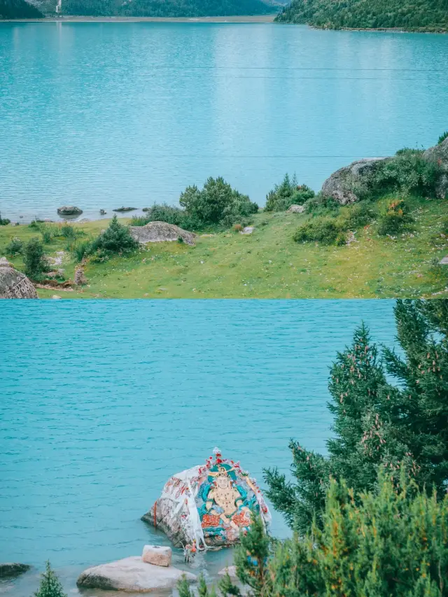 My favorite lake in western Sichuan is small and beautifulMy favorite lake in western Sichuan. I found that most people who come to western Sichuan will not go to this line and see this treasure lake. It's so beautiful and the surroundings are rich, but everyone just doesn't want to come here to play. That is the Xinlu Sea along the 317 Ganzi County line, also called Yulong Laco. I heard about the big name of Xinlu Sea a long time ago. The main reason for being attracted to it is the color of its lake water, which is a kind of milky green. This is not particularly many in the whole Tibetan area. Jiuzhaigou is peacock blue, Tiffany blue, Yamdrok Lake in Tibet is Klein blue, Daocheng Milk Sea is azure, but the color of Xinlu Sea is rare milky green. It should be due to the melting water of the glacier on the side of the lake. It is said that the glacier meltwater will present a milky color. Secondly, the scenery on the shore of Xinlu Sea is very rich, with snow-capped mountains, grasslands, streams and flowers, and the huge stones in the lake are engraved with scriptures, and the white tower is flying with prayer flags. What is particularly beautiful is the pine tree of Xinlu Sea, tall and independent, reflecting the mountains and seas, especially like the scene in the movie. How to go? Navigation Yulong Laco. It's right next to National Highway 317, and the car goes straight. How to play? Xinlu Sea only needs to pay a sanitation fee of 20 yuan, and then you can go in and play at will. This is not a formal scenic spot, so it is very open. But it is said that camping is not allowed inside now, only outside. The highlight of this attraction in summer is the grassland and flowers, and the green pine trees. But in winter! Autumn is also very beautiful. Because in summer, the snow on its snow-capped mountains is relatively weak, but in autumn and winter, the snow-capped mountains in the distance are spectacularly white, highly recommended. Moreover, in autumn, the lake water will be bluer. In winter, it will freeze and you can see a large area of blue ice. In addition, there are many scenic spots around Xinlu Sea, which can be played together. Xinlong Red Mountain Scenic Area Sanlian Lake Zaxi Chilin Temple Dege Sutra Printing House Zhuqing Temple Queer Mountain Viewing Platform The above attractions can be connected with Xinlu Sea in one or two hours, and the scenery of each attraction is different. How long to play? If Xinlu Sea is slow-paced, you can actually stay for half a day, blowing the lake wind and dazing. If it's fast-paced, 2 hours.HarmoniousHavensByTaylor
 Travel to Western SichuanIt is recommended to spend 4-5 days on this route. You will see both natural and cultural scenery here. D1: Chengdu - Kangding - Provincial Road 434 - Tagong - Daofu D2: Daofu - Garze County - Xinluhai - Dege D3: Dege Juehe Ranch - Garze County D4: Garze County - Ganbai Road - Yaqing Temple - Garze County - Daofu (You can go directly to Baiyu to Batang without going back, and then take the 318 back, which will take longer.)PhoenixGlowstone881
 I like to live in a place where I can see snow mountains or the sea. Yulong Lacuo is the Tibetan name of Xinluhai. It is said that the hero of the famous Tibetan epic "Gesar King Biography" came to the lake and was attracted by the beautiful lakes and mountains and the quiet environment. The lake is lingering on the side of the lake, and her heart that mourns the beautiful rivers and mountains is still at the bottom of the sea. In order to commemorate the Zhumu, the descendants named Yulong Lacuo, meaning the heart of the holy lake. The lake water has different colors due to seasonal changes. It may be due to the influence of the rainy season, and the clouds in the sky are thicker, the lake is slightly turbid, like a pool of milk, very beautiful and quiet. Very small attractions, worth a look. The end of Xinluhai is a few snow-capped mountains. The end of the lake is not far from the end, but it is such a small lake. It takes an hour or two to walk to the end. There are strange rocks on the lakeside. When we entered the new road, we took off our coats and took pictures. But the more we went inside, the darker we went, and then we looked at the lake and guessed why the water was this color, but walked away. I felt the snow fell on my body and looked up. The snow-capped mountains at the top of the snow began to snow.makiori.
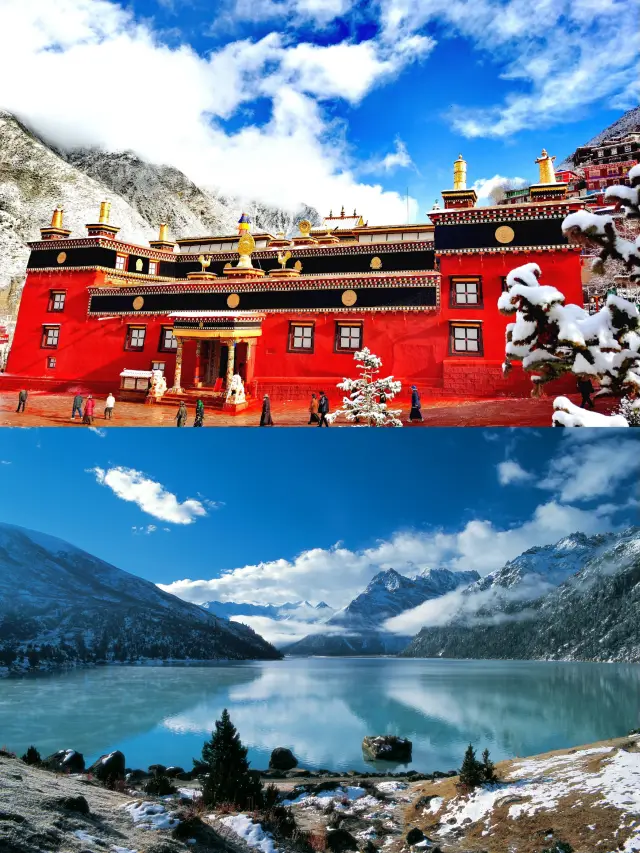
 Soon after Dege came out, it was necessary to climb the highest road in Sichuan, the famous dangerous road on the Sichuan-Tibet Highway - Queer Mountain. This is not an easy path. The mountain body of Queer Mountain is composed of granite intrusion. After the action of flowing water and glaciers, the peaks and peaks are jagged, and people in the mountains are like being in the world. As if to appease our frightened eyes, and down the Queer Mountain, it is the famous ice-etching lake in Ganzi Prefecture - Xinluhai. Here, tenderness is like water. The melting of the Queer Mountain glaciers and snow is continuously injected into the new road sea, and the stream flowing from the lake tail is one of the sources of the Tuqu River. "Xinluhai" is said to be named after the road-building army of the Sichuan-Tibet Highway. Its Tibetan name is Yulong Lacuo, which is related to the woman of King Gesar. I dont know if its related, but the beauty of Yulong Lacuo is refined. Surrounded by plateau spruce, fir, cypress, rhododendron and meadows, the lake is surrounded by blue sky and white clouds, snow-capped peaks, glacier flashes, green mountains, green grass and sparkling clouds. Yulong Lacuo is the dojo of the Tibetan Buddhist auspicious Sakya Yulong Lagar Temple and the living place of Shengle King Kong. The white snow mountain of Yulong Lacuo is the dojo of Guanyin Bodhisattva. The overlapping peaks are the dojo of the Vajrapani Bodhisattva. The yellow grassland in the east is the dojo of Manjushri. Every year, the yellow sand in the lake will naturally emerge from the Tibetan calendar. The beautiful blue waters of the lake alternate with different colors as the seasons. Yulong Lacuo's face is like the flowers in the years, fresh and elegant. Your serene beauty forms a beautiful style on the Sichuan-Tibet Northern Line. If you have never seen the green lake and flowing white clouds of Yulong Latcu, you may regret it for a long time... a green water, lying quietly in the mountains In the embrace of the morning, the thin mist of the morning is filled with the water above the lake. There is a kind of fairyland meaning, quiet and auspicious. Perhaps only one of the unknown birds in the morning swept past the lake to break the silence that seemed to solidify. By the lake, many Mani stones stand on the undulating grass. The devout Tibetan compatriots are engraved on the stone with solemn vajronogini, Manjushri, Vajrapani Bodhisattva, Guanyin Bodhisattva, Lotus Master, Vajrasattva and many other Buddha statues, as well as the seeds and spells of the Buddhas and Bodhisattvas. The holy six-character mantra of Mani Stone is a natural success. In the Capricorn of the years, the spirit and blessings are integrated into the heavens and the earth.makiori.
Nearby Attractions
Dege Parkhang Sutra-Printing House | 昌都市江達縣崗託鎮崗託村 | Gengqing Temple | Duopugou Scenic Area | Babang Temple | 康巴文化博覽園 | Jixiang Wala Temple | Gangtuo Bridge | XiangBaLa BuXingJie | Galong | Aizhanglong | Moputong | Zhe'anlong | Shailalong | Duojilong | Bawuke | Duo'er Jiagou | Suoboke | Nimolong | Balilong | Maxilong | Yangcuo | Dege Cultural Center | Juenalong | Yanghailong | Oupulong | Puyuanma | Gama | Cilalong | Mailonglong
Popular Types of Attractions in Dege
Nature | Mountains | Grasslands | Lakes | Religious Sites | Historic Sites | Historical Sites | Ancient Towns | Ancient Pagodas | Traditional/Cultural Experiences | Architecture & Landmarks | Bridges | Squares | Exhibition Centers | Museums | Memorial Halls | Outdoor Sports | Mountain Climbing | Hiking | Lifestyle
Popular Restaurants in Dege
Popular Destinations
Bangkok Travel | Barat Travel | Hong Kong Travel | Tokyo Travel | Seoul Travel | Shenzhen Travel | Manila Travel | Singapore Travel | Kuala Lumpur Travel | Hangzhou Travel | Chengdu Travel | Macau Travel | Chongqing Travel | Phnom Penh Travel | Sange Travel | Stephenville Travel | Genting Highlands Travel | Bintulu Travel | Gabaldon Travel | Wuyuan Travel | Bakale Travel | Torkadwadi Travel | Salvinde Travel | Dhanaechaatter Sueya Malkhanpu Travel | Chanduki Travel | Indri Grant Travel | Parasa Mafi Travel | Pakhopur Travel | Beel Akbarpur Travel | Mohammadpur Taluka Madpur Sult Travel
Recommended Attractions at Popular Destinations
Bangkok attraction near me | Tokyo attraction near me | Manila attraction near me | Hong Kong attraction near me | Seoul attraction near me | Taipei attraction near me | Los Angeles attraction near me | New York attraction near me | Shanghai attraction near me | Kuala Lumpur attraction near me | Shenzhen attraction near me | Guangzhou attraction near me | Osaka attraction near me | Singapore attraction near me | London attraction near me | San Francisco attraction near me | Beijing attraction near me | Macau attraction near me | Bali attraction near me | Paris attraction near me | Orlando attraction near me | Jakarta attraction near me | Ho Chi Minh City attraction near me | Phuket attraction near me | Chicago attraction near me | Toronto attraction near me | Cebu attraction near me | Dallas attraction near me | Istanbul attraction near me | Dubai attraction near me
Popular Trip Moments
Dege Free Travel | Comprehensive Guide for Qingming Festival Tourism | Going to Western Sichuan, you really need a telephoto lens! | 10-day self-driving tour guide for the small loop in Western Sichuan | Come to Queer Mountain, cross the dangerous situation, and face the magnificent scenery of heaven! | Who hasn't been to this little-known secret place in Western Sichuan | Xieqing Temple - Pilgrimage to the Hundred Ancient Temples Series One | My favorite lake in western Sichuan is small and beautiful | Travel to Western Sichuan | Self-driving tour of Sichuan Qingxiaohuan Line (Seventeen) Queer Mountain | Self-driving tour of Sichuan Qingxiaohuan Line (Fifteen) Dege Sutra Printing House
More Things To Do in Dege
China eSIM Day Pass/data Package days selected without cards QR code | China Mainland/Hong Kong/Macau eSIM (QR Code) | China Mainland eSIM|China Mobile Unlimited 4G High Speed Data | China, Hong Kong, and Macau eSIM|Total 5GB/10GB/15GB/20GB High-speed 4G LTE Unlimited high-speed data | Asia・Australia eSIM|AIS SIM2Fly 8 days 6GB High-speed Unlimited 5G/4G Data | Mainland China eSIM |China Mobile 4G high-speed unlimited data eSIM | [China Mainland] eSIM | SIM to China | 8GB 8days 4G high speed | Mainland China + Hong Kong + Macau eSIM 4G Data Daily Plan QR Code | Trip.SIM Japan, South Korea, Macau, Taiwan and many places in Asia + Australia and New Zealand 4G travel data roaming phone network card 4 days/7 days | eSender - Mainland China eSIM daily package/traffic package, days optional. No need to get the card QR code | Mainland China + Hong Kong + Macau eSIM Data Plan QR Code | China/Hong Kong/Macau eSIM high-speed network for travel/business | China, Hong Kong, Macau 4G SIM Card (HK, Macau, Taiwan, China Delivery Only) | [China, Hong Kong and Macau] 4G network | Unlimited traffic | Self-pickup at the airport | WiFi rental, high-speed traffic, shared by multiple people, ready to use at startup, 12H standby, 24H customer service | Global multi-region A series eSIM|High-speed data, travel and business Internet access, optional unlimited data, optional days, QR code | Global multi-region B series eSIM|Universal in 54 countries Travel and business Internet access Optional unlimited data Optional days QR code | Mainland China eSIM high-speed traffic, no card required QR code | 【5G SIM Card】China・National 5G Universal SIM Card |Total 10GB/15GB/30GB/45GB High-speed 5G Unlimited Data Service (Pick up at Shanghai Pudong T2) | Global eSim for 140+ countries (sent via email) by Xplori | Asia 9 Regions eSIM 4G Data Daily Plan QR Code | eSIM for China, Hong Kong and Macau. Universal for Mainland China/Hong Kong/Macau. Optional days for travel and business. QR code | Asia 9 Destinations eSIM 4G Data Plan QR Code | Global (30 Countries) eSIM Data Package (QR Code) | AIS Global esim data package (QR code) | Global multi-region C series eSIM|Common in 84 countries Travel and business Internet access Optional unlimited data Optional days QR code | eSender- Brunei/Indonesia/Singapore/Japan and many other countries and regions eSIM daily package/data package (QR code) | China, Macau eSIM - Data plan by Gohub (QR Code) | AIS Asia esim data package (QR code) | China 4G SIM Card (HK, Macau, Taiwan, China Delivery Only) | China Travel SIM Card
Payment Methods
Our Partners
Copyright © 2024 Trip.com Travel Singapore Pte. Ltd. All rights reserved
Site Operator: Trip.com Travel Singapore Pte. Ltd.
Site Operator: Trip.com Travel Singapore Pte. Ltd.
Yulong Lacuo is located in Queer Shandong Province, at an altitude of 4040 meters, formed by glacier erosion, and replenished by ice and snow melt water. Yulong Lacuo is a sudden towering glacier snow peak in the south, and the pasture of the village of Tsuo, where the grass is abundant, and the east and west sides are dense with plateau spruce and meadows. Here ecological primitive, lush vegetation, lift the eyes of snow peaks, low head wild Fang, there are wild ducks swimming fish play in the water, lama tourists wandering on the lake, a fairyland on earth, paradise.
The Yulong Laqu Scenic Area, located in Dege County, Ganzi Prefecture, Sichuan Province, has beautiful scenery, but each person charges 30 yuan without tickets and no supporting facilities, and there is no road construction due to the scenic spot. No guide map, no sign, guide card, no public toilet, etc.
The main reason why Yulong Lacuo Scenic Area is so beautiful and the scenery is moving? The main reason is that the snow water of the snowy mountain glacier melts, resulting in the various green plants in Pingba that look very good.
I looked at the sharing of many friends. The quality of the shot was not flattering, so I had to clarify it again (Tiffany Blue): The most beautiful lake in western Sichuan, do not accept rebuttals, the copy is pale, look at the picture and talk
Xinluhai, the largest pearl on the northern Sichuan-Tibet line, Haizi is not big, the road to go is not easy, in August 2015, the road is difficult to walk. With the floor mat, carrying butter tea, being dry grain, setting up a tent, came to the longing new road sea. Sitting by the sea for a day, I saw the sea in the rain, the snowy mountains in the sun, and the Dianchi Lake with dark clouds. I feel that the hardships on the road are nothing more than this.