OverviewBookNearbyReviewsWin PrizesRecommended
Share to
Wushao Mountain Range
烏鞘嶺3.7
19 Reviews
Recommended sightseeing time:0.5-1 day
Address:
Tianzhu, Wuwei, ChinaMap
What travelers say:
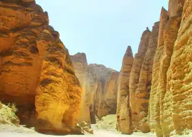
乌鞘岭位于甘肃省武威市天祝藏族自治县中部,属祁连山脉北支冷龙岭的东南端。为陇中高原和河西走廊的天然分界,也是半干旱区向干旱区过渡的分界线,也是东亚季风到达的最西端。东西长约17公里,南北宽约10公里,主峰海拔3562米,年均气温-2.2℃,志书对乌鞘岭有"盛夏飞雪,寒气砭骨"的记述,是古丝绸之路上河西走廊通往长安的重要关隘。
MoreSaved by 1
Wushao Mountain Range Highlights: Must-See Features and Attractions
Some information may have been translated by Google Translate
Wushaoling is located in the middle of Tianzhu Tibetan Autonomous County, Wuwei City, Gansu Province, and belongs to the southeastern end of Lenglongling, the northern branch of Qilian Mountains. It is the natural boundary between the Longzhong Plateau and the Hexi Corridor, the boundary between the semi-arid area and the arid area, and the western end of the East Asian monsoon. The east-west length is about 17 kilometers, the north-south width is about 10 kilometers, the main peak is 3562 meters above sea level, and the average annual temperature is -2.2 ℃. The chronicle of Wushaoling has a description of "midsummer flying snow, cold air and Bianstone bone", which is Hexi on the ancient Silk Road. The corridor leads to an important pass in Chang'an.
Explore near Wushao Mountain Range: Where to Stay, Eat, and Visit
Wushao Mountain Range Reviews: Insider Insights and Visitor Experiences
Some reviews may have been translated by Google TranslateWrite a Review
/5
Excellent ReviewsAll (19)
Latest
With Photos (13)
Positive Reviews (7)
- 1
- 2
- 3
- 4
You Might Also Like
Jingtai Yellow River Stone Park
6.4
4.2/5725 Reviews
Lanzhou Yellow River Cruise
6.8
4.3/5216 Reviews
Longwu Temple
4.3
4.6/555 Reviews
Save US$2.07
From US$6.22
Nearby Attractions
華藏寺 | Shimengou Prairie Park | Tianzhu Zangzu Zizhixian Museum | Dashagou Ruins | qing long shan gong yuan | Yongdeng Library | Yongdeng Museum | People's Park | Dachaigou Mosque | Shangtan | 慄家莊漢墓 | 濱河森林公園 | 葯水神泉 | 天祝藏族自治縣圖書館 | Jinqiangyi Mosque | Bianmaxia | Erjiaxia | Bingxia | La Xuanmaxia | Longtanhe | Huo Shigouxia | Tuchenghe | Shimenhe | Wushengyi Mosque | Dazhazi | Xi'erqu | 永登縣獎俊埠林場 | Xisanqu | Dong'erqu | 石家灘
Popular Types of Attractions in Tianzhu
Nature | Mountains | Lakes | Forests | Religious Sites | Churches and Cathedrals | Temples | Mosques | Exhibition Centers | Museums | Memorial Halls | Exhibition Halls | Architecture & Landmarks | Squares | Featured Neighborhoods | Historical Architectures | Lifestyle | Campgrounds | Libraries | Resorts | Parks | City Parks | Botanical Gardens | Water Parks | Historic Sites | Historical Sites | Cemeteries | Ancient Towns | Traditional/Cultural Experiences | Villages
Popular Restaurants in Tianzhu
Hongseyinxiangzhuticha Restaurant | 伊品源餐厅 | 泽成冰煮羊(天祝店) | 克勤羊羔肉餐厅(华藏嘉园小区店) | 快乐星汉堡 | 隆昌泰农家院 | DONG FANG GE YAN YIN LE CAN BA | 十八褶火锅店 | 你我他转转小火锅(金沙居店) | 珍爵丛林狼 | 伊泊尔牛肉面馆 | Benxiaohaishouzuohongbei (guangchang) | 小龙坎火锅(天祝店) | 红玖玖海鲜自助火锅 | 锦悦坊家宴 | CHA ZHI LIN | 第九味自助火锅(天祝店) | 伊隆餐厅 | 云臻轩人文茶楼 | Qishanxujiaganmianpi | TAI HE NIU ROU LA MIAN GUAN | 湘鸭村火锅店天祝店(天祝店) | 老马家羊羔肉餐厅 | 吾茶 | 金龙乐园 | 可百可(金沙巷店) | 疯狂烤吧 | 清丰斋手抓餐厅 | 汉堡皇快餐店 | 金福鼎羊肉面片
Popular Destinations
Lanzhou Travel | Picton Travel | Melton Mowbray Travel | Sabah Travel | Hat Yai Travel | Phi Phi Islands Travel | La Trinidad Travel | Claveria Travel | Baler Travel | Colombo Travel | Hurghada Travel | Boracay Island Travel | Munich Travel | Tonglu Travel | Xishuangbanna Travel | Christmas Island Travel | Qingyuan Travel | Samal Island Travel | Port Dover Travel | Amman Travel | Dohis Travel | Mazeyrat-d'Allier Travel | Ishkly Travel | Vanoise National Park Travel | Lordelo do Ouro Travel | Steuben County Travel | Chinatown/Little Italy Travel | Quebec City Travel | Casalecchio di Reno Travel | Klatovy Travel
Recommended Attractions at Popular Destinations
Bangkok attraction near me | Tokyo attraction near me | Manila attraction near me | Hong Kong attraction near me | Seoul attraction near me | Taipei attraction near me | Los Angeles attraction near me | New York attraction near me | Shanghai attraction near me | Kuala Lumpur attraction near me | Shenzhen attraction near me | Osaka attraction near me | Singapore attraction near me | Guangzhou attraction near me | London attraction near me | San Francisco attraction near me | Beijing attraction near me | Macau attraction near me | Bali attraction near me | Paris attraction near me | Ho Chi Minh City attraction near me | Orlando attraction near me | Jakarta attraction near me | Phuket attraction near me | Chicago attraction near me | Toronto attraction near me | Istanbul attraction near me | Cebu attraction near me | Dallas attraction near me | Seattle attraction near me
More Things To Do in Tianzhu
China eSIM Day Pass/data Package days selected without cards QR code | China Mainland/Hong Kong/Macau eSIM (QR Code) | China Mainland eSIM|China Mobile Unlimited 4G High Speed Data | China, Hong Kong, and Macau eSIM|Total 5GB/10GB/15GB/20GB High-speed 4G LTE Unlimited high-speed data | Mainland China eSIM |China Mobile 4G high-speed unlimited data eSIM | Asia・Australia eSIM|AIS SIM2Fly 8 days 6GB High-speed Unlimited 5G/4G Data | [China Mainland] eSIM | SIM to China | 8GB 8days 4G high speed | Mainland China + Hong Kong + Macau eSIM 4G Data Daily Plan QR Code | Trip.SIM Japan, South Korea, Macau, Taiwan and many places in Asia + Australia and New Zealand 4G travel data roaming phone network card 4 days/7 days | [China, Hong Kong and Macau] 4G network | Unlimited traffic | Self-pickup at the airport | WiFi rental, high-speed traffic, shared by multiple people, ready to use at startup, 12H standby, 24H customer service | eSender - Mainland China eSIM daily package/traffic package, days optional. No need to get the card QR code | China/Hong Kong/Macau eSIM 4G high-speed network QR code | China, Hong Kong, Macau 4G SIM Card (HK, Macau, Taiwan, China Delivery Only) | Mainland China + Hong Kong + Macau eSIM Data Plan QR Code | Global multi-region A series eSIM|High-speed data, travel and business Internet access, optional unlimited data, optional days, QR code | Global (30 Countries) eSIM Data Package (QR Code) | Global multi-region C series eSIM|Common in 84 countries Travel and business Internet access Optional unlimited data Optional days QR code | eSIM for China, Hong Kong and Macau. Universal for Mainland China/Hong Kong/Macau. Optional days for travel and business. QR code | Lanzhou Private Day Tour of Tianti Grottoes, Luoshi Pagoda and Leitai | [Hong Kong, Mainland China] 4G Internet Card | China Unicom/Hutchison | Unlimited data SIM card | Optional days | Insert the card and use | Self-pickup at Hong Kong Airport | Mainland China eSIM high-speed network QR code | Asia 9 Regions eSIM 4G Data Daily Plan QR Code | [Mainland China] 4G Internet Card|China Unicom|Unlimited Data SIM Card|Number of Optional Days|Insert the card and use it|Self-pickup at Hong Kong Airport | China Travel SIM Card | China 4G SIM Card (HK, Macau, Taiwan, China Delivery Only) | AIS SIM2Fly Global eSIM|15 days 6GB high-speed 4G/5G Unlimited Data | Lanzhou Ink Painting Danxia Scenic attraction Half-Day Tour [One order, one group/door-to-door pick-up/pure play Chartered Vehicle to encounter beautiful Danxia/go whenever you want without waiting] | Global eSim for 140+ countries (sent via email) by Xplori | Asia 9 Destinations eSIM 4G Data Plan QR Code | [Mainland China, Hong Kong and Macau] 4G Internet Card|China Unicom/Hutchison/CTM|Unlimited data SIM card|Number of optional days|Insert the card and use|Self-pickup at Hong Kong Airport
Payment Methods
Our Partners
Copyright © 2024 Trip.com Travel Singapore Pte. Ltd. All rights reserved
Site Operator: Trip.com Travel Singapore Pte. Ltd.
Site Operator: Trip.com Travel Singapore Pte. Ltd.
乌鞘岭位于甘肃省武威市天祝藏族自治县中部,属祁连山脉北支冷龙岭的东南端。为陇中高原和河西走廊的天然分界,也是半干旱区向干旱区过渡的分界线,也是东亚季风到达的最西端。东西长约17公里,南北宽约10公里,主峰海拔3562米,年均气温-2.2℃,志书对乌鞘岭有"盛夏飞雪,寒气砭骨"的记述,是古丝绸之路上河西走廊通往长安的重要关隘。
我国的八大沙漠中,后套平原与西套平原之间有两块,青藏高原上有一块,剩下的五块全部都在乌鞘岭以西,那是一片沙漠与戈壁并存的海洋,也是一片与黄土高原截然不同的别样天地,大漠孤烟、长河落日、塞下秋风、胡马羌笛,无不透漏着与中土风情完全迥异的异域色彩,造成这种地域差异的主要原因应该就是乌鞘岭了。
黄土高原与河西走廊并不是无缝对接的,中间还横着一只拦路虎叫乌鞘岭。在张骞凿通西域之前,人们不知道在黄河的西边还有这么一条通道,更不知道走廊的尽头就是西域,对于山那头的情况基本上是两眼一抹黑,一无所知,一切都是显得那么的神秘,其根本原因就是因为这条乌鞘岭的存在。围就青藏高原的祁连山脉在靠近黄河的时候,向两侧延伸出了三条最主要的支脉,分别是湟水谷地两侧的拉脊山与达板山,还有就是向东延伸出来的乌鞘岭。乌鞘岭一头拉着祁连山脉,另一头接在了腾格里沙漠上,正好把黄土高原挡在了岭外,
非季风区,也就是那条地理分界线以西、以北的区域,由于受喜马拉雅山脉的阻挡,印度洋的水汽根本过不来,而太平洋的水汽最远也只能到了祁连山最东端的乌鞘岭。
河西走廊的起点,也是中原进入河西地区的第一道屏障。常年大风严寒。翻越很艰难,西游记里有介绍呃。暖湿气流在这御阻,形成大规模降雨可能。