OverviewBookNearbyReviewsWin Prizes
Share to
Zhada Tulin
札達土林4.8
168 Reviews
 based on 9 reviews
Recommended sightseeing time:1-2 hour
Address:
Within Zada County, Ali DistrictMap
What travelers say:
Leaving the town of Talchin in Gangrenboqi, arriving at Zada Tulin in the afternoon, located in Arizada County. It has been transformed by geological changes in the ancient Great Lake Basin and the big river bed for thousands of years. [View] Good [Interesting] Good [Cost-effective] Very high
More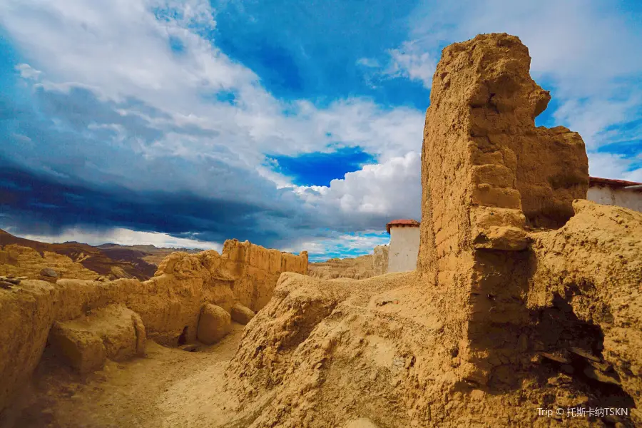
See all 18 photos
Saved by 2
Zhada Tulin Highlights: Must-See Features and Attractions
Some information may have been translated by Google Translate
Zanda soil forest is a special geological landform formed by the influence of orogeny, and the stratum deposited at the bottom of the lake has been cut by running water for a long time and gradually weathered and denuded. The "trees" in the soil forest are scattered up to tens of meters high and low, and the cars are moving in a circle, like looping around the soles of many giants. As a special landform combination, Zanda soil forest has a variety of shapes. Macroscopically, along the banks of the Xiangquan River, there are undulating, layered forests, steep and gentle, and vast soil forest groups. A rare "earth forest landform" spectacle. These peculiar "soil mountain and forest" landforms are formed under the influence of the Himalayan orogeny in the lake basin sedimentary layer where the area was located in ancient times, as the water level fell, the lake basin was raised, and was formed under the erosion and cutting of climate and river water. of. The steep and precipitous rocks look like towering castles, watchtowers, pagodas, etc. It is a famous natural landscape in the Ali area. However, about 1,100 years ago, in the same afterglow, stood the palaces and temples of the once-powerful Guge Kingdom. From the existing ruins, we can imagine the huge scene at that time, which is far from comparable to the current situation. Viewing point: The Xiangquan River Valley platform a few hundred meters south of the county seat is a good place to view the soil forest. Shooting point: On the square near the Tuolin Temple, dozens of meters deep beside the square, is the wide and flat Xiangquan River network water system. The soil forests on both sides of the river valley are vertical and horizontal, like a castle, a pagoda, a Buddha, a The palace stretches for dozens of kilometers.
Explore near Zhada Tulin: Where to Stay, Eat, and Visit
Zhada Tulin Reviews: Insider Insights and Visitor Experiences
Some reviews may have been translated by Google TranslateWrite a Review
 (168 Reviews)Trip.com
 (9 Reviews)TripAdvisor
/5
Outstanding ReviewsAll (168)
Latest
With Photos (137)
Positive Reviews (62)
- 1
- 2
- 3
- 4
- 34
Frequently Asked Questions About Zhada Tulin
Nearby Attractions
Ruins of the Kingdom of Guge | Tholing Monastery | Piyang Dongga Cave Site | Mummy Cave | Zanda Tuolin Square | Guge Scenery Spot | 札達土林國家地質公園-託林寺遺跡 | 億佳俱樂部 | 瑪琅觀景台 | Martyrs' Cemetery | Zhada National Geological Park Xiangquan River | Zhada Earth Earth Forest National Geological Park - Gangsang Earth Forest | Zhada Earth Earth Forest National Geological Park - Castle Style Earth Forest | Zhada Earth Earth Forest National Geological Park - Tian'an Xixia (Imbricate Earth Forest) | Zhada Tulin National Geological Park - Dingdingka Rangeland (Xuefengshi Tulin) | Zunda Tulin National Geological Park - gravel-bearing soil forest | Zhada Earth Forest National Geological Park - Meiguipu Bahrain (Pingding Style Earth Forest) | Zhada Earth Earth Forest National Geological Park - Geru Caves | Zhada National Geological Park Jianmutarang (Ridge-Shaped Earth Forest) | Zhukang | Jiyalong | Juemaqu | Zhada Earth Earth Forest National Geological Park - Naga Zisheng Tower (Tower Style Earth Forest) | Zhada Earth Forest National Geological Park - Zisheng Tower Style Earth Forest | Zhada National Geological Park Jibudajiutang (Step-Shaped Earth Forest) | Mang Qingzangbu | Malangqu | Zhada National Geological Park Earth Forest Jiabudingzhiling (Throne of the King) | Zhada Earth Earth Forest National Geological Park - Ancient Bell Style Forest
Popular Types of Attractions in Zhada
Popular Restaurants in Zhada
香百城重庆小面 | 鑫隆门涮烤小火锅 | 川王食府(河北路中段店) | 伊兰美食 | 湘味居湘菜馆 | 天堂时光书店 | 川粤饭庄 | 山城酒家(河北路中段店) | 重庆人家 | 伊鑫美食城 | 一品香川菜 | 川渝火锅 | 高原生态汤锅(帕拉路店) | 岗嘎底斯餐厅 | 刘胖子川菜风味羊杂馆(帕拉路店) | 重庆餐厅 | 冒椒火辣(帕拉路店) | 李记老山城小面 | 食来食往 | 快手石锅川菜馆 | Honglajiaochuan Restaurant | 札达县川渝味道川菜馆 | 乐蒙汉堡 | 重庆粉面馆 | 古格象雄茶馆 | 老陕面馆 | Zhadaxinyutesecai | 渝味重庆小面(河北路中段店) | 温迪士蛋糕 | 成渝中餐厅
Popular Destinations
Vung Tau Travel | Narathiwat Travel | Edinburgh Travel | Cagayan De Oro Travel | Budapest Travel | Warsaw Travel | Jiaxing Travel | Malaga Travel | San Carlos City Travel | Intramuros Travel | Beach City Travel | Baler Travel | Atok Travel | Yangzhou Travel | Roanoke Rapids Travel | Chuncheon-si Travel | San Juan Teotihuacan Travel | Addis Ababa Travel | Riyadh Travel | Amphoe Mueang Phuket Travel | Zhukivka Travel | Uxeau Travel | Saint-Mars-du-Desert Travel | Confracourt Travel | Anetz Travel | Culoz Travel | Nerbis Travel | Broye Travel | Krsinji Vrh Travel | Purkace Travel
Recommended Attractions at Popular Destinations
Bangkok attraction near me | Tokyo attraction near me | Manila attraction near me | Hong Kong attraction near me | Seoul attraction near me | Taipei attraction near me | Los Angeles attraction near me | New York attraction near me | Shanghai attraction near me | Kuala Lumpur attraction near me | Shenzhen attraction near me | Guangzhou attraction near me | Osaka attraction near me | Singapore attraction near me | London attraction near me | San Francisco attraction near me | Beijing attraction near me | Macau attraction near me | Bali attraction near me | Paris attraction near me | Orlando attraction near me | Jakarta attraction near me | Ho Chi Minh City attraction near me | Phuket attraction near me | Chicago attraction near me | Toronto attraction near me | Cebu attraction near me | Dallas attraction near me | Istanbul attraction near me | Dubai attraction near me
More Things To Do in Zhada
China eSIM Day Pass/data Package days selected without cards QR code | China Mainland/Hong Kong/Macau eSIM (QR Code) | China Mainland eSIM|China Mobile Unlimited 4G High Speed Data | China, Hong Kong, and Macau eSIM|Total 5GB/10GB/15GB/20GB High-speed 4G LTE Unlimited high-speed data | Asia・Australia eSIM|AIS SIM2Fly 8 days 6GB High-speed Unlimited 5G/4G Data | Mainland China eSIM |China Mobile 4G high-speed unlimited data eSIM | [China Mainland] eSIM | SIM to China | 8GB 8days 4G high speed | Mainland China + Hong Kong + Macau eSIM 4G Data Daily Plan QR Code | Trip.SIM Japan, South Korea, Macau, Taiwan and many places in Asia + Australia and New Zealand 4G travel data roaming phone network card 4 days/7 days | eSender - Mainland China eSIM daily package/traffic package, days optional. No need to get the card QR code | [China, Hong Kong and Macau] 4G network | Unlimited traffic | Self-pickup at the airport | WiFi rental, high-speed traffic, shared by multiple people, ready to use at startup, 12H standby, 24H customer service | Mainland China + Hong Kong + Macau eSIM Data Plan QR Code | China/Hong Kong/Macau eSIM high-speed network for travel/business | China, Hong Kong, Macau 4G SIM Card (HK, Macau, Taiwan, China Delivery Only) | Global multi-region A series eSIM|High-speed data, travel and business Internet access, optional unlimited data, optional days, QR code | Mainland China eSIM high-speed traffic, no card required QR code | [FLASH SALE] China, Hong Kong, Macau eSIM - Data plan by Gohub (QR Code) | Asia 9 Destinations eSIM 4G Data Plan QR Code | Asia 9 Regions eSIM 4G Data Daily Plan QR Code | eSender- Brunei/Indonesia/Singapore/Japan and many other countries and regions eSIM daily package/data package (QR code) | Global (30 Countries) eSIM Data Package (QR Code) | Global eSim for 140+ countries (sent via email) by Xplori | China 4G SIM Card (HK, Macau, Taiwan, China Delivery Only) | Global multi-region B series eSIM|Universal in 54 countries Travel and business Internet access Optional unlimited data Optional days QR code | China, Macau eSIM - Data plan by Gohub (QR Code) | China, Hong Kong, Macau eSim 1/3/7/15/30 days (sent via email) by Xplori | China Travel SIM Card | 【5G SIM Card】China・National 5G Universal SIM Card |Total 10GB/15GB/30GB/45GB High-speed 5G Unlimited Data Service (Pick up at Shanghai Pudong T2) | eSIM for China, Hong Kong and Macau. Universal for Mainland China/Hong Kong/Macau. Optional days for travel and business. QR code | AIS Asia esim data package (QR code)
Payment Methods
Our Partners
Copyright © 2024 Trip.com Travel Singapore Pte. Ltd. All rights reserved
Site Operator: Trip.com Travel Singapore Pte. Ltd.
Site Operator: Trip.com Travel Singapore Pte. Ltd.
Leaving the town of Talchin in Gangrenboqi, arriving at Zada Tulin in the afternoon, located in Arizada County. It has been transformed by geological changes in the ancient Great Lake Basin and the big river bed for thousands of years. [View] Good [Interesting] Good [Cost-effective] Very high
Zada Tulin is located in the area of Zanda County in Ali District, is the most famous landform scenic area in Zanda County, Xiangquan River walks through it, the earth forest is full of shapes and majestic, driving here to visit, like walking in a picture scroll. The Guge Dynasty site is located in the earth forest, the Guge Dynasty was the collapse of Tubu, by the Tubu descendants of the King, to the death of around 1630, its reign lasted for 700 years (the Central Plains Dynasty exceeded 300 years), it is rumored to have hereditary 16 kings.
Zada Tulin is located in Arizada County, located between Gangdisi Mountain and Himalaya Mountains. There is a magnificent earthy mountain forest along the Xiangquan River Valley, known as the "Zada Tulin", which is made from ancient lake basins and river beds through geological changes. The forest of nearly hundreds of square kilometers is full of high and low "woods", different forms, showing the ghosts and magic of nature.
The environment is first-class, the scenery is unique, and the transportation is convenient. It is a good place to take pictures.
Zada earth forest landscape at altitude of 4500 is a great wonder of Ali, and the inexhaustible skill is as if you are on another planet, which is very shocking.