OverviewNearbyReviewsWin PrizesRecommended
Share to
Sasagamine
笹ヶ峰1.0
 based on 6 reviews
Address:
Saijo 793-0000, Ehime PrefectureMap
What travelers say:
See 1 photo
Explore near Sasagamine: Where to Stay, Eat, and Visit
Sasagamine Reviews: Insider Insights and Visitor Experiences
Write a Review
 Trip.com
 (6 Reviews)TripAdvisor6 Reviews
You Might Also Like

Universal Studios Japan
10
4.8/518657 Reviews
From US$54.73

Shikoku Aquarium
3.8
4.5/53 Reviews
From US$18.42
Nijō Castle
7.7
4.6/51610 Reviews
From US$8.37
Umeda Sky Building
7.3
4.6/5794 Reviews
Save US$0.58
From US$9.08
Nearby Attractions
Nikobuchi | Ino Town Paper Museum | Sugimoto Shrine | Kochi Castle | Hakawa Park | Hirome Market | Katsurahama | Green Park Hodono | Harimaya Bridge | Kochi Park | The Kochi Prefectural Makino Botanical Garden | Edagawa Park | The Sakamoto Ryoma Memorial Museum | Sakamoto Ryoma Statue | Noichi Zoological Park | Katsurahama Aquarium | Chikurinji Temple | Kochi Castle Museum of History | Nakatsu Gorge | Central Park | Tosa Shrine | Nishijima Horticultural Park | TOHO Cinemas Kochi | Shikoku | The Museum of Art, Kochi | Katsuobune | Hakawa Park River Lands | Sakamoto Ryoma's Hometown Museum | Haruno-no-yu | Kochi Athletic Recreation Park
Popular Types of Attractions in Ino
Parks | City Parks | Botanical Gardens | Amusement Parks | Religious Sites | Other Places of Worship | Temples | Churches and Cathedrals | Exhibition Centers | Museums | Art Museums | Art Galleries | Architecture & Landmarks | Monuments | landmark | Observation Decks | Historic Sites | Historical Sites | Cemeteries | Castles | Lifestyle | Hot Springs | Entertainment Centers | Libraries | Popular Spots | Nature | Attractions | Lakes | Mountains | Fitness
Popular Restaurants in Ino
Kochi Ice | Kissa Shichisaikan | Nozomi | Nihiki No Kobuta | Frying Pan | Kura | Rotating Sushi Sushi Ikkan Ino | Restaurant Aogi | Small Market @Deli Sunny Axis Ino | Tokiya Handmade Soba | Misuzu | Ichinotani Yakata | Rest House Shimizu | Oishinbo Yamaoka | Erupio | Restaurant Kisara | Misono | O Sushi Furusato | Coffee Kobo Yu | Nikonikokan | License | Chimbo | Wakadori | Warabetei | Miraku | Old New | Itadoritei | Yakitori Daikichitenno | Yakiniku Choju | Ekimae Sakaba
Popular Destinations
Dali Travel | Urumqi Travel | Los Angeles Travel | Tea Gardens Travel | Nanshan District Travel | Malaysia Travel | Zhangjiajie Travel | Jiuzhaigou Travel | Dhaka Travel | Nagoya Travel | Johannesburg Travel | Kunming Travel | Xishuangbanna Travel | Mattinata Travel | Walldorf Travel | Yangzhou Travel | Yichang Travel | Lovell Travel | Turvelandia Travel | Grekovo-Petrovskiy Travel | Majh Gaon Travel | Kantovka Travel | Corrego do Ouro Travel | Pipehra Travel | Gringley on the Hill Travel | Lac-Marguerite Travel | Novye Semivragi Travel
Recommended Attractions at Popular Destinations
Bangkok attraction near me | Tokyo attraction near me | Manila attraction near me | Hong Kong attraction near me | Taipei attraction near me | Seoul attraction near me | Los Angeles attraction near me | New York attraction near me | Shanghai attraction near me | Kuala Lumpur attraction near me | Shenzhen attraction near me | Osaka attraction near me | Singapore attraction near me | Guangzhou attraction near me | London attraction near me | San Francisco attraction near me | Beijing attraction near me | Macau attraction near me | Bali attraction near me | Paris attraction near me | Ho Chi Minh City attraction near me | Orlando attraction near me | Jakarta attraction near me | Phuket attraction near me | Chicago attraction near me | Toronto attraction near me | Istanbul attraction near me | Cebu attraction near me | Dallas attraction near me | Seattle attraction near me
More Things To Do in Ino
Japan eSIM | SoftBank/IIJmio Unlimited 4G high-speed data(Natural day) | Asia 8 countries eSIM 4G high-speed network QR Code | Asia・Australia eSIM|AIS SIM2Fly 8 days 6GB High-speed Unlimited 5G/4G Data | Japan eSIM | Unlimited 4G High Speed Data (1 day = 24 hours) | Japan eSIM | Unlimited 5G high-speed data | Trip.SIM Japan, South Korea, Macau, Taiwan and many places in Asia + Australia and New Zealand 4G travel data roaming phone network card 4 days/7 days | Japan 4G SIM Card (HK, Macau, Taiwan, China Delivery Only) | Global multi-region A series eSIM|High-speed data, travel and business Internet access, optional unlimited data, optional days, QR code | Global Regions eSIM|Unlimited 4G High Speed Data | eSIM Japan by Gohub | [General in Asia] 4G network | Unlimited traffic | Self-pickup at the airport | WiFi rental, high-speed traffic, shared by multiple people, ready to use at boot, 12H standby, 24H customer service | 【Japan eSIM】Japan eSIM with Unlimited High-speed Data | [Unlimited Data] Japanese 4G/5G High-speed WiFi Sharer-Hong Kong Airport Pickup (Provided by WiFiBB) | Japan eSIM|High-speed data, travel and business Internet access, optional unlimited data, optional days, QR code | [Japan] 4G Internet Card|CMI|Unlimited Data SIM Card|Number of Optional Days|Insert the card and use it|Self-pickup at Hong Kong Airport | 【Hiroshima NADAMAN】 OMAKASE Kaiseki | eSender - Japan eSIM daily package/data package (QR code) | Sea kayaking tour with lunch! A one-day adventure by sea kayak in Hiroshima | Port Pick-Up: Kochi Tour with Licensed Guide and Vehicle | Global multi-region B series eSIM|Universal in 54 countries Travel and business Internet access Optional unlimited data Optional days QR code | [Japan eSIM] Japan au eSIM with Unlimited 5G/4G Local Data (No throttling) | [Japan] 4G Internet Card|docomo|30-day optional package|Insert the card and use it|Self-pickup at Hong Kong Airport | Matsuyama Half-Day Private Trip with Government-Licensed Guide | AIS SIM2Fly Global eSIM|15 days 6GB high-speed 4G/5G Unlimited Data | Kochi Full-Day Private Trip with Government-Licensed Guide | Global eSIM 4G/5G high-speed network QR code | Sea Kayak Tour to the History of Tomonoura in the Seto Inland Sea | [Global use] 4G network | Unlimited traffic | Self-pickup at the airport | WiFi rental, high-speed traffic, shared by multiple people, ready to use at boot, 12H standby, 24H customer service | AIS Global esim data package (QR code) | Wakimachi BROMPTON Bicycle Tour
Payment Methods
Our Partners
Copyright © 2024 Trip.com Travel Singapore Pte. Ltd. All rights reserved
Site Operator: Trip.com Travel Singapore Pte. Ltd.
Site Operator: Trip.com Travel Singapore Pte. Ltd.
Mountaineering Pass
A mountain on the prefectural border between Ehime Prefecture and Kochi Prefecture. I think it's better to run on the forest road from the Ehime Prefecture side. I feel that the parking lot is a little inconvenient, but I recommend it.
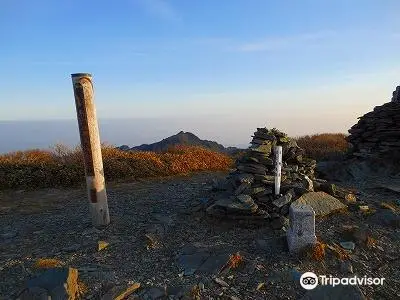
It is a mountain with a height of 1860m at the easternmost end of the Ishigaki mountain range.
I went to climb the three famous mountains of Iyo. It has a longer history than Mt. Ishigaki, and Fudo Myoo is enshrined at the top. It is a nice mountain when viewed from the SAIJO city side. As the name suggests, the area near the top of the mountain is a Sasa plateau. I went by car to the trailhead via Shimotsu Pond on the SAIJO side. It takes about two and a half hours from the trailhead to the top.
I climbed the next day of climbing Mt. Ishigaki.
It is a mountain selected as one of the 200 famous mountains in Japan and is connected to Mt. Ishigaki. From Komatsu IC on the Matsuyama Expressway, you will arrive at the trailhead via the Sasagamine Forest Road. This distance is about 30km. You can rest assured that there is a parking lot. The mountain climbing is about 900m in height and about 4 hours and 9km round trip to the top of the mountain. There is also a toilet and water in Maruyamaso on the way.
Stone Hammer Lianfeng 80km away
Sasagamine reached by running vertically through Ishigayama, Bingamori, Iyofuji, and Mt. Kanfu. As the name suggests, the area near the top of the mountain is covered with bamboo grass, and it is attractive that there is no big tree 々 and the view is good. There are mountain climbing courses from north, south, east, west, and all courses are maintained so you can stand on the top of the mountain with peace of mind. The popular course that is often used is the Maruyama Ski Resort Course on the Ehime Prefecture side, and you can go back and forth to the top of Mt. Sasagamine in about 5 hours.
The pass of the old road passes
It is a pass on the prefectural border between Kochi and Ehime prefectures. The altitude is 1027 meters and the former Tosa Kaido runs through it. Nowadays, the two prefectures are connected by national highways, highways, and the Tosan Main Line, but they all pass through different places or pass through tunnels at once. Currently, the prefectural road extends to the pass and crosses directly under the pass by tunnel. The quiet pass is suitable for a leisurely drive.