


1 / 9
Mentioned in This Moment
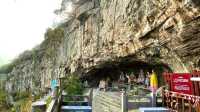
4.3/513 reviews | Rivers
Hebi
View
Show More
Where to go on the weekend? Let's head to Hebi
Maximus_Hawkwood
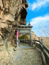
Off-the-Beaten-Path Attraction | Chaoge Old Street
MADDISON BARNETT
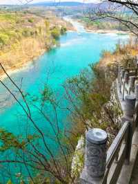
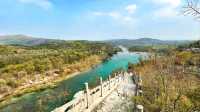
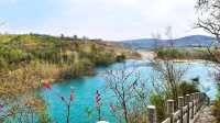
Relaxing holidays by the Qi River
octavia_serene_morgenstern
How to play in Hebi, Henan?
JULIANNA WARNER
Popular Trip Moments
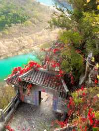
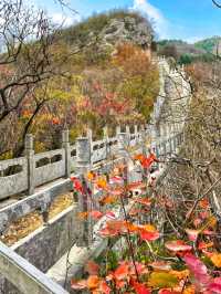
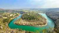
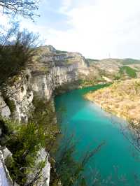
Where to go on the weekend? Let's head to Hebi | Chaoyang Mountain in Hebi, a natural fairyland hidden in the mundane world! | Guling Mountain in Jun County, Henan, is a breathtakingly beautiful place, like a paradise away from the hustle and bustle of the world | Off-the-Beaten-Path Attraction | Chaoge Old Street | Ancient Village (Part 3) Qi County • Tao Hu Quan Village|||In the mountains, a village built of stones | Explore the Hebi Cherry Blossom Garden: A Comprehensive Guide to Cherry Blossom Viewing! | Relaxing holidays by the Qi River | Cao Wei Ancient City - A Journey through the Culture of the Three Kingdoms | 【Cloud Dream Mountain Secret Realm】Unveil the secluded dwelling of the Warring States strategists and experience the wisdom of ancient military tactics | Henan 'Chaoge' City | Detailed guide to Yunmeng Mountain Scenic Area | Off-the-beaten-path recommendation | Xunxian Ancient City | The generous treatment of members by Hampton is praiseworthy | How to play in Hebi, Henan? | First time in Hebi, a new Chinese-style hotel! | Tracing Henan Hebi·Xunxian Ancient City·Day | Mo Shang Qing Ju, Hebi Yimeng | "Poetic Beauty" - Moshi Light Residence Hotel | In a county town - the ancient charm of the Mo's Light Dwelling Hotel | The romance of Kunming has many aspects, and the winter cherry blossoms on Cherry Blossom Avenue is one of them | Natural Tai Chi Diagram Tourist Scenic Area, the pride of China | Xunxian Ancient City | Embark on a 1 | Be a free wind, rushing towards the mountains and fields
Popular Travel Types
Popular Destinations
San Francisco Travel | Budha Basoda Travel | Balamban Travel | Sirumalai Travel | Singapore Travel | Jiangxi Travel | Shenyang Travel | Kaohsiung Travel | Zhengzhou Travel | Moscow Travel | Rafah Travel | Taipei Travel | Kampot Travel | Redang Island Travel | Malaybalay Travel | Shimizu Travel | Quezon City Travel | New Cairo City Travel | Wuhu Travel | Pasay Travel | Khirdipatode Travel | Home Township Travel | Sorbs Travel | Nachni Ghat Travel | Daegu Central Area Travel | Mogendorf Travel | Cottonwood County Travel | Chapo-Ologo Travel | Kainthra Travel | Laplacette Travel
Recommended Attractions at Popular Destinations
Bangkok attraction near me | Tokyo attraction near me | Manila attraction near me | Hong Kong attraction near me | Taipei attraction near me | Seoul attraction near me | Los Angeles attraction near me | New York attraction near me | Shanghai attraction near me | Kuala Lumpur attraction near me | Shenzhen attraction near me | Osaka attraction near me | Singapore attraction near me | London attraction near me | Guangzhou attraction near me | San Francisco attraction near me | Beijing attraction near me | Macau attraction near me | Bali attraction near me | Paris attraction near me | Ho Chi Minh City attraction near me | Orlando attraction near me | Jakarta attraction near me | Phuket attraction near me | Chicago attraction near me | Toronto attraction near me | Fukuoka attraction near me | Istanbul attraction near me | Dallas attraction near me | Cebu attraction near me
Popular Attractions
Cloud Nine Hot Spring | Venice Town | Ashikaga Flower Park | "The Song of Everlasting Sorrow" | Singapore Flyer | Window of the World | Thousand Island Lake | Happy Valley Beijing | Keukenhof | Shanghai Ocean Aquarium | Penida Island | Tokyo Joypolis | Nijō Castle | Baiyun Mountain Cableway | Marina Bay Sands | Guangfulin Relics Park | Chinese Dinosaur Park | B&O Bike Trail | Caffe Nina | De Watertoren | Rappahannock River Heritage Trail | Old West Church | Memorial Wall of Light Rail Builders | Tunisia Happy Land Park | Xinhuajie Wenti Square | Brewery Liefmans | Nusa Dua | Impression Sanjie Liu (Evening Showtime) | Tokyo DisneySea | Tokyo Tower
Popular Restaurants in Hebi
建业大食堂(鹤壁店) | TIAN FU KUAI KE LAI XIN OU DIAN | BAI NIAN LAO MA | 老革命火锅 | 德克士(中凯店) | 中凯铂爵酒店·中餐部 | 必胜客(鹤煤大道店) | DQ | Weidaomingchu | 全朋老火锅 | CHONG QING PIAN PIAN YU LAO OU DIAN | 徐氏湘菜(鹤壁店) | Xianglong Cake (benliujie) | 三国烤肉(华夏北路店) | Tudalikaoroumingjia (hebi) | 特色包子楼 | 德克士(浚县店) | LAO LANG DA PAN JI XIN OU DIAN | 德克士(华夏南路裕隆店) | XIAO XING AN LING TE CHAN | 白石的深夜食堂(淇滨万达店) | 肯德基(银鹤店) | 阿上阿上(爱之城店) | 川庄火锅 | BA LAO SAN HUI MIAN HUAI HE LU DIAN | 巴奴毛肚火锅(鹤壁万达店) | 东北小胖墩(万达直营店) | 巴蜀菌汤火锅(天山路店) | 呷哺呷哺(鹤壁万达店) | 不二料理(衡山路店)
Payment Methods
Our Partners
Copyright © 2024 Trip.com Travel Singapore Pte. Ltd. All rights reserved
Site Operator: Trip.com Travel Singapore Pte. Ltd.
Site Operator: Trip.com Travel Singapore Pte. Ltd.