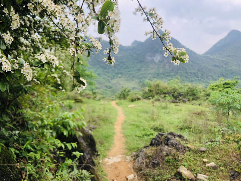
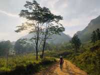
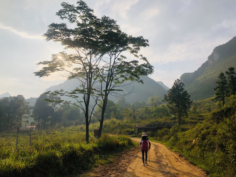
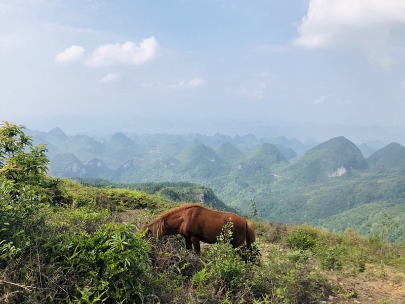
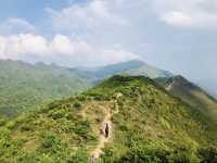
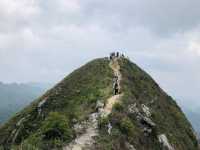
Qingyuan Moliugong Mountain is a popular place for outdoor enthusiasts in Guangdong. Walking on the small ridges of the mountains, you can see the continuous mountains, and you need a certain amount of physical strength to climb up!
;
Moliugong Summit Review
4.8 /519 Reviews


1 / 9


4/5
Moliugong Summit
Posted: Sep 10, 2020
Like
 5/5OutstandingOriginal Text
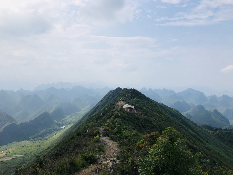
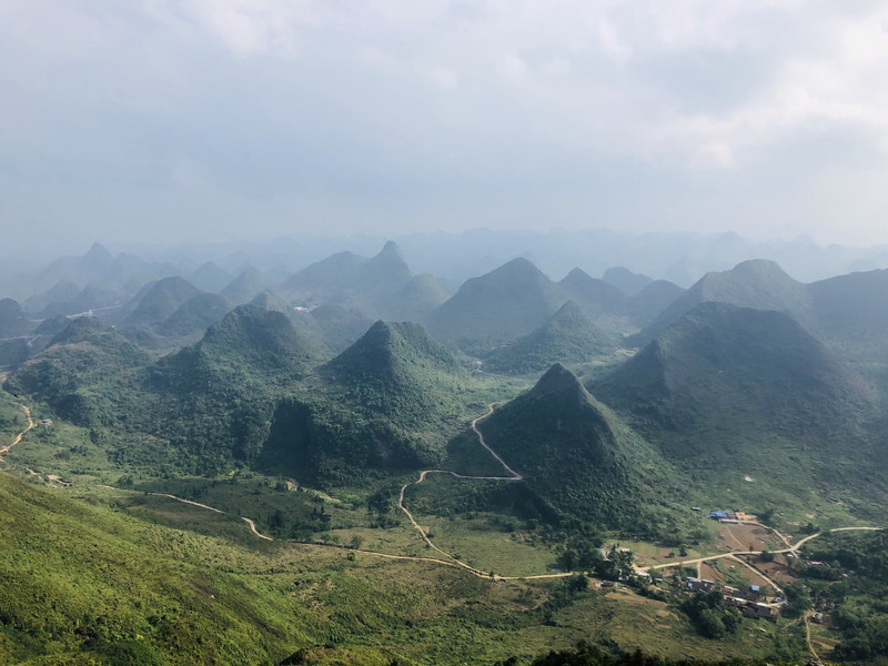
Damei Qingyuan: Mo Liugong Mountain is the first peak of Yangcheng Town Qishan (1178 meters by sea) Weifeng, 1027 meters by sea, and Heping Village is under the mountain. Walking on the long ridge line of Moliugong, you can see the endless grass slope, which can be compared with Wugong Mountain and the top of the boat. It is surrounded by beautiful karst peaks. From the top of the mountain, you can overlook the endless conical peaks... Today, 8 kilometers of hiking, walking for 5 and a half hours, experienced cloudy days, A moment of sunny days, thunderstorms, muddy mountain roads...
Posted: May 17, 20202 5/5OutstandingOriginal Text
Mo Liugong is a popular hiking place in Qingyuanyang Mountain, Guangdong. It features a view of the karst landscape peaks and forests. There are no trees on the long ridge line on foot, not a scenic spot, it is worth a visit!
Posted: Jun 14, 20230 5/5OutstandingOriginal Text
Looking at the picture is not as good as starting, choose April and May. UV is particularly strong, do a good job of sun protection, a bottle of mineral water is not enough
Posted: Jun 18, 20200 Original Text
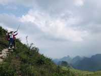
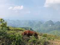
🏔 Qingyuan Moliugong Mountain, as one of the "Guangdong's top ridge hiking routes", the combination of karst landform villages and hiking routes of ridge meadows is its unique existence! Looking out over the mountains of karst landforms, like the rolling hillside meadows of Xiaoguilin, compared to Wugong Mountain walking on the top of the ridge, standing between the sea of clouds, like a fairyland. There is no despair of Wugong Mountain, this is a beautiful scenery, suitable for Xiaobai hiking route; It is also a place to shoot ink, sunset, sea of clouds, starry sky photography! .Recommended line 1⃣: regular small loop line 7KM hiking 🏃 time: 3-6 hours Easy entry-level outdoor line, suitable for novice, two steps down the track, 3 supply points, the last one is for starry sky campground, there are catering and tents! 🚗 Self-driving navigation: Yangshan Heping Moliugong Visitor Reception Center in Qingyuan City 🅿️ Parking fee: 20 yuan. Recommended line 2⃣: Leisure climbing to the top to watch the starry sky and sea of clouds 🏃 Play: 1-3 Hours from the climbing road of the starry sky camp, half an hour can climb to the top, walking on the ridge, suitable for wanting to watch the sunset and sea of clouds. Friends who shoot blockbuster movies! .⛺️ There are camping, dining and supply 🚗 Self-driving: Navigate the Hengshanshui Moliugong Starry Sky Camp in Qingyuan City. You need to open the mountain road. It is recommended that SUV 🅿️ parking fee: 20 yuan. #Summer you will most play #Play outdoor #Outdoor Base Camp
Posted: Aug 7, 20220 Original Text
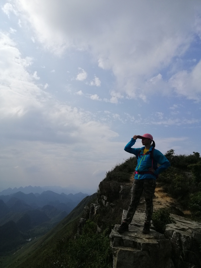
#I am a travel player Guangzhou Qingyuan Moliugong Dingshan hiking line, this is one of Guangdong's top ridge hiking lines, Moliugong Dingshan, 1005 meters above sea level, walking in Moliugong long ridge line, thousands of beautiful karst peaks, shadows. After climbing to the top, the view is wide, 360 degrees unobstructed, and the scenery is beautiful, but the sun is also warm and unobstructed to shine on you. Below, I share the precautions to be paid attention to on foot and the suggestions for avoiding pits. If you don't like it, don't spray. 1. At present, the management of the scenic spot is not perfect, and it is not recommended to go freely. There is no clear route sign in the scenic spot. It depends on the ribbon code of the traveler to remind you to hike. The road is difficult. It takes about 6 hours to walk the entire ring road. 2. From the Moliugong Mountain Visitor Center to the first half slope supply point, it is a overgrown dirt road almost vertically up the mountain, which is a very test of physical strength. Be careful not to wear shoes on the bottom of the book. After the first supply point, you have to turn over a few mountains (about 3 hours) to reach the second peak supply point. The road is far away, the sun is unobstructed on the ridge, and there is no one along this road, and there is a certain risk in the wilderness. 3. With enough water and dry food, we can't rely on the supply point to replenish. We each brought 1.5L on the water mountain. We had finished drinking when we arrived at the first supply point. Fortunately, there were mung bean water and other drinks at the supply point, but the supply point was not long-term. Someone was there. When we left, The only staff at the recharge point also took the dog and closed the door. We reached the second recharge point at the top of the mountain at 6 pm. There was no one there and there was no recharge. Fourth, after the second recharge point, go down the mountain to the foot of the mountain, and the navigation shows that there are still four kilometers to return to the visitor center! This route is more than 6 hours, suitable for people who like it very much and have a certain hiking experience, enjoy the fun of hiking, not suitable for the general physical strength, no hiking experience traveler. It is not suitable for travelers who like to see the scenery, take pictures, and take leisure vacations. Because the scenery along the way is beautiful but very simple, the feeling of Yingxi Peak Forest, the knife-like vision of the ridge is the vision of the drone, people stand on the top of the mountain to see, the scenery is actually very ordinary and not steep. We flew two drone aerial shots, and the scenery was single. Five, the locals told us that it would be closer to Yushui Village. Climbing up the top of the mountain is the second supply point, and then going to the first supply point, but the starting point of the car to the foot of the mountain is poor, and there is a section of the stone road that has not been repaired. Six, found on the way: we took the spectacular Dubu Bridge at Xuguang Expressway, the bridge is relatively high 110 meters, once the largest relative high difference in the entire South China region, is a beautiful scenery. The viaduct is a beautiful scenery. #The most beautiful aerial photography #My hiking punch card notes #Qingyuan Yangshan Mo Liugong Mountain #Guangzhou Surrounding Tour
Posted: Aug 5, 20220- 1
- 2
- 3
- 4
Popular Destinations
New Delhi Travel | Tashkent Travel | Cagayan De Oro Travel | Venua Travel | Kota Kinabalu Travel | Mumbai Travel | Incheon Travel | Alykel' Travel | Angola-on-the-Lake Travel | Valencia Travel | Edinburgh Travel | Al Aziziyah Travel | Bangkok Travel | Cornwell Travel | Kerala Travel | Fakfak Travel | Penghu Travel | Mytilene Travel | Zhaoqing Travel | Elysburg Travel | Gemeinde Stinatz Travel | Kharapa Travel | Tabalbala Travel | Novopavlivs'ke Travel | Demusa Travel | Periban Travel | Mulliken Travel | Sonnewalde Travel | Kanhrawala Travel | Potrk Travel
Recommended Attractions at Popular Destinations
Bangkok attraction near me | Manila attraction near me | Tokyo attraction near me | Taipei attraction near me | Hong Kong attraction near me | Seoul attraction near me | Los Angeles attraction near me | New York attraction near me | Shanghai attraction near me | Kuala Lumpur attraction near me | Shenzhen attraction near me | Osaka attraction near me | London attraction near me | Singapore attraction near me | Guangzhou attraction near me | San Francisco attraction near me | Beijing attraction near me | Macau attraction near me | Bali attraction near me | Paris attraction near me | Jakarta attraction near me | Ho Chi Minh City attraction near me | Orlando attraction near me | Phuket attraction near me | Toronto attraction near me | Chicago attraction near me | Cebu attraction near me | Seattle attraction near me | Istanbul attraction near me | Dallas attraction near me
Popular Attractions
Chimelong Water Park | Universal Orlando Resort | Underwater World Pattaya | Sleep No More | Angkor Wat | Top of Shanghai Observatory | Shichahai Bar Street | Playa Maya | Shenzhen Ping An Financial Center Yunji Sightseeing | Universal Studios Hollywood | Aqua Club Dolphin | Haedong Yonggung Temple | SeaWorld San Diego | Shanghai Science and Technology Museum | Heineken Experience | Kanas Lake Scenic Area | Xichong | Dandong Juvenile Children Library (6th Latitude Road) | Midway Speedway | Honmyoji | Theresa Catholic Church | Rikotti | Barracao Theater | Mayura Ayurvedic Centre | Catholic Church (Northwest to Anning Mansion) | Mokhwa Bowling | Hengjin Reservoir | Muangboran the Ancient City (Samut Prakan) | Yuanmingyuan Park | Patong Boxing Stadium Sainamyen
Popular Travelogues
Bangkok Travelogue | Manila Travelogue | Tokyo Travelogue | Taipei Travelogue | Hong Kong Travelogue | Seoul Travelogue | Los Angeles Travelogue | New York Travelogue | Shanghai Travelogue | Kuala Lumpur Travelogue | Shenzhen Travelogue | Osaka Travelogue | London Travelogue | Singapore Travelogue | Guangzhou Travelogue | San Francisco Travelogue | Beijing Travelogue | Macau Travelogue | Bali Travelogue | Paris Travelogue | Jakarta Travelogue | Ho Chi Minh City Travelogue | Orlando Travelogue | Phuket Travelogue | Toronto Travelogue | Chicago Travelogue | Cebu Travelogue | Seattle Travelogue | Istanbul Travelogue | Dallas Travelogue
Popular Ranked Lists
Popular Family-friendly Attractions Near Songzi | Top 20 Local Restaurants in New York | Popular Premium Hotels Near Gorod Bryansk | Top 16 Local Restaurants in Weihai | Popular Family-friendly Attractions Near Shizong | Top 16 Local Restaurants in Edinburgh | Top 20 Local Restaurants in Huangshan | Popular Family-friendly Attractions Near Luohe | Popular Premium Hotels Near Kohka | Popular Luxury Hotels Near Uberlingen | Popular Luxury Hotels Near Pemenang | Popular Family-friendly Attractions Near Yichang | Popular Family-friendly Attractions Near Zhongmu | Popular Luxury Hotels Near Durajaya | Popular Family-friendly Attractions Near Xinzheng | Top 18 Local Restaurants in Dunhuang | Popular Family-friendly Attractions Near Nanyang | Popular Luxury Hotels Near Chatel | Top 10 Local Restaurants in Kota Kinabalu | Popular Local Restaurants in Hong Kong | Popular Luxury Hotels Near Chessy | Popular Luxury Hotels Near Kotohira | Popular Family-friendly Attractions Near Turpan | Popular Luxury Hotels Near Bac Lieu | Top 19 Local Restaurants in Kobe | Top 18 Local Restaurants in Xishuangbanna | Top 19 Local Restaurants in Urumqi | Popular Luxury Hotels Near Tongdao | Popular Luxury Hotels Near Odawara
Payment Methods
Our Partners
Copyright © 2024 Trip.com Travel Singapore Pte. Ltd. All rights reserved
Site Operator: Trip.com Travel Singapore Pte. Ltd.
Site Operator: Trip.com Travel Singapore Pte. Ltd.