OverviewNearbyReviewsWin PrizesRecommended
Share to
Kabasaka Toge
刈場坂峠1.7
 based on 4 reviews
Address:
Ono, Tokigawa-machi, Hiki-gun 355-0366, Saitama PrefectureMap
What travelers say:

See all 6 photos
Explore near Kabasaka Toge: Where to Stay, Eat, and Visit
Kabasaka Toge Reviews: Insider Insights and Visitor Experiences
Write a Review
 Trip.com
 (4 Reviews)TripAdvisor4 Reviews
You Might Also Like
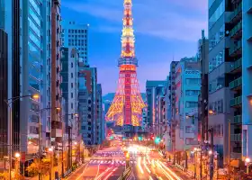
Tokyo Tower
8.2
4.7/53619 Reviews
From JPY 1,200

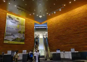
The National Museum of Emerging Science and Innovation
6.6
4.3/5434 Reviews
From JPY 630
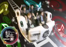
Tokyo Joypolis
6.3
4.6/5189 Reviews
-JPY 840
From JPY 4,160
Mori Art Museum
6.2
4.6/5237 Reviews
From JPY 4,107
Nearby Attractions
Ghibli Museum | Sanrio Puroland(Tokyo) | MOOMINVALLEY PARK | Tove Jansson Akebono Children's Forest Park | Miyazawako Onsen Kirari, Annex | Mumin Valley Park | Koedo-kawagoe | Moomin House | Hanno Riverbank | Musashigaoka Golf Course | Ne-no-gongen | Hanno City Central Park | Mount Takao | Kichijōji | Arima Dam | Azu Sports Park | Kawagoe Hikawa Shrine | Takedera | Togo Park | Mt. Tenran Observation Deck | The Railway Museum | Hanno Kusunoki Country Club | Inokashira Park | Noninji Temple | Tama Zoological Park | Kurazukuri no Machinami / Little Edo Warehouse District | Saitama Super Arena | Kawagoe Kita-in Temple | Showa Memorial Park | Tokyo Summerland
Popular Types of Attractions in Hanno
Parks | City Parks | Amusement Parks | Botanical Gardens | Religious Sites | Other Places of Worship | Temples | Churches and Cathedrals | Exhibition Centers | Museums | Art Museums | Art Galleries | Lifestyle | Hot Springs | Entertainment Centers | Libraries | Architecture & Landmarks | Monuments | landmark | Featured Neighborhoods | Historic Sites | Historical Sites | Castles | Cemeteries | Popular Spots | Nature | Lakes | Mountains | Attractions | Outdoor Sports
Popular Restaurants in Hanno
Resutoranizupasshon | Menyamujinzo | Starbucks Coffee, Hanno PePe | La NoLa | Nakayama Chaya | Oyasumi Dokoro Yamasemi | Tonmaru | Asami Chaya | Chinese Restaurant Hibika | Gusto, Hanno | Chojuan | Chukasoba Tsukesobasenmonten Momokawa | Fukurokuju | Temmatsu Midori-Cho | Yakiniku Gyuzaburou | Kongoen | Yakiniku Senka | Machiko | Yamaki | Modern Pasta Hanno | Kaoburi Chaya | Hikobe | Turnip | Surugaya | Spaghetti House Nabe | Kyubeya Higashi Hanno Ekimae-Dori | Ishidaya Confectionary Store | Cafe Misugi | Mos Burger, Beruku Hanno | Ontake Udon
Popular Destinations
New Cumberland Travel | Urumqi Travel | Los Angeles Travel | Dublin Travel | Xiamen Travel | Malaysia Travel | Candelaria Travel | La Cienega de Gonzalez Travel | Port Dover Travel | Shenzhen Travel | Zhuhai Travel | Guilin Travel | Kunming Travel | Maldives Travel | Phra Nakhon Travel | Summerton Travel | Siam Travel | Panglao Travel | Tongxiang Travel | Reinoso Travel | Gemeinde Stinatz Travel | Kharapa Travel | Dakwadi Travel | Novopavlivs'ke Travel | Demusa Travel | Jhawoil Gram Travel | Villa Progreso Travel | Virovo Travel | Kanhrawala Travel
Recommended Attractions at Popular Destinations
Bangkok attraction near me | Manila attraction near me | Tokyo attraction near me | Taipei attraction near me | Hong Kong attraction near me | Seoul attraction near me | Los Angeles attraction near me | New York attraction near me | Shanghai attraction near me | Kuala Lumpur attraction near me | Shenzhen attraction near me | Osaka attraction near me | London attraction near me | Singapore attraction near me | Guangzhou attraction near me | San Francisco attraction near me | Beijing attraction near me | Macau attraction near me | Bali attraction near me | Paris attraction near me | Jakarta attraction near me | Ho Chi Minh City attraction near me | Orlando attraction near me | Phuket attraction near me | Toronto attraction near me | Chicago attraction near me | Cebu attraction near me | Seattle attraction near me | Istanbul attraction near me | Dallas attraction near me
Popular Ranked Lists
Popular Premium Hotels in Abona | Top 15 Local Restaurants in Christchurch | Top 10 Local Restaurants in Kathmandu | Top 6 Bars in Chun'an | Popular Premium Hotels in Klaeng | Popular Family-friendly Attractions Near Gaoyang | Popular Family-friendly Attractions Near Yiwu | Popular Family-friendly Attractions Near Haicheng | Popular Family-friendly Attractions Near Shaodong | Popular Family-friendly Attractions Near Luxi | Top 4 Bars in Kanazawa | Popular Premium Hotels in Kumano | Popular Premium Hotels in La Cerdanya | Popular Premium Hotels in Multnomah County | Top 5 Premium Hotels in Haut-Rhin | Top 16 Local Restaurants in Weihai | Top 3 Premium Hotels in Aristotelis | Popular Family-friendly Attractions Near Daishan | Popular Family-friendly Attractions Near Lianshan | Top 6 Bars in Yanji | Popular Luxury Hotels Near Estremoz | Top 4 Bars in Naha | Popular Family-friendly Attractions Near Jainca | Popular Family-friendly Attractions Near Le'an | Popular Family-friendly Attractions Near Ejin Horo Banner | Popular Family-friendly Attractions Near Funing | Popular Luxury Hotels Near Bartow County | Popular Family-friendly Attractions Near Linwu | Top 7 Bars in Izmir
Popular Travel Types
More Things To Do in Hanno
Japan Transportation Pass - Seibu Railway + Kawagoe 1-Day Pass | Moominvalley Park: Ticket & Travel Pass | Japan Transportation Pass - Seibu Railway One-Day Pass | Japan Transportation Pass - Seibu Railway One-Day Pass + Nagatoro | Tokyo Metro METRO + Toei Subway One-day Pass/Two-Day Pass/Three-Day Pass|Tokyo Metro + Toei Subway 24/48/72-hour Ticket | Mount Fuji Day Tour to Lake Kawaguchi, Nikkawa Timetable and Oshino Hakkai | Tokyo Mt. Fuji Day Trip (6-9 people in a small group, popular attractions, horse ranch, Nikkawa, optional hotel pick-up and drop-off) | Japan eSIM | SoftBank/IIJmio Unlimited 4G High Speed data(Natural day) | Japan Tokyo Mount Fuji one-day tour[Selected popular attractions Hakone/Kawaguchiko/optional hotel pick-up] | one-day tour before Kamakura High School in Tokyo, Japan [Kamakura flower viewing tour/Enoshima/Slam Dunk filming location/Hase Temple/Enoshima/Chinese and English] | Asia・Australia eSIM|AIS SIM2Fly 8 days 6GB High-speed Unlimited 5G/4G Data | Japan Bus ticket Shinjuku to Mount Fuji Station Kawaguchiko Fujikyu Two-way Bus ticket electronic ticket (scan the code to get on the bus + no ticket exchange required) | JR East Tohoku Area 5-Day Railway Pass (Electronic Ticket) | Japan eSIM | SoftBank Unlimited 4G High Speed Data (1 day = 24 hours) | Global (66 Countries) eSIM Data Package (QR Code) | Japan Fujinomiya City Mt. Fuji + Yamanakako + Kawaguchiko Music Box Forest Museum Day Tour [Tokyo City/Surrounding Chartered Vehicle |Chinese and English Drivers|Adjustable Itinerary| Hotel Pickup] | Private Transfer from Haneda Airport (HND) to Tokyo City Center | Japan Yokohama + Zushi Beach + Tsurugaoka Hachimangu Shrine one-day tour[Yokohama Fireworks Festival・SDGs Future City | August 5 Limited | Summer Fireworks from Tokyo] | Private Airport Transfer from Narita Airport to Tokyo | 1 Day Mount Nokogiri Hiking Tour from Tokyo | Mt. Fuji Private Tour with English Speaking Guide | Tachikawa City to Tokyo Haneda Airport (HND) - Departure Private Transfer | Tokyo Family Tour with a Local Guide, Private & Tailored to You | Tokyo Food Tour: An afternoon in Nakameguro! | Tokyo's Scariest Shitamachi Ghost Tour | Discovery more Private Trip to Mt. Fuji with English Driver | Hakone Open-Air Museum + Izu Jogasaki Coast 2-Day Tour [Hydrangea Tram/Little Kyoto Shuzenji Hot Spring/Shimoda Park/Ryugu Cave/Bamboo Forest Trail] | Atami Full-Day Private Tour with Government-Licensed Guide | Find out tasty and historical places | Licensed Guide Kabukicho Shinjuku Nite Experience Tour(Tokyo)
Payment Methods
Our Partners
Copyright © 2024 Trip.com Travel Singapore Pte. Ltd. All rights reserved
Site Operator: Trip.com Travel Singapore Pte. Ltd.
Site Operator: Trip.com Travel Singapore Pte. Ltd.
there were hunting maggots gathered here.
I drove the Oku Musashi Green Line from the south to Karibazaka Pass. There was a large parking lot here. Today seems to be the day of the lifting of the ban on hunting, and many hunters were gathering. This is the boundary from Hanno City to Tokigawa Town. It is a view from Karabazaka Pass. If you go a little north, you will find a paraglider departure and arrival point, and the mountains around here will blow in a windy direction! There is Mt. Dohira and there is Mt. Dohira. There is Mt. Azalea nearby. From here ...
Pass now です.
The road leading from National Highway 299 is closed as of December due to the typhoon in October this year. If you are going, please check the road situation.
It is a pass with a good view.
It is a pass in the middle of the Oku Musashi Green Line. I stopped by during the hike, but it is a pass with a good view. I walked from Mt. Dohira on that day, but I can also see Mt. Dohira. If you turn your eyes, you can see the Kanto Plain. Also, there are several large cherry trees, so I think you should have wonderful flowers during the cherry blossom season. It's a good place to take a break.
It's a nice pass.
On the way to the Oku Musashi Green Line, it is at the confluence with the road climbing from the vicinity of the Shomaru Pass of R299. The north direction is blocked by Mt. Dohira, but the view of the Kanto Plain in the northeast is wonderful. Please stop the car for a moment and look at the scenery.