OverviewNearbyReviewsWin PrizesRecommended
Share to
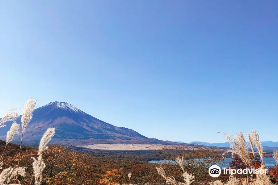
Mikuni Toge Observatory
三国峠展望台1.0
 based on 9 reviews
Open year round, 24/7
Address:
Fukara, Susono 410-1102 Shizuoka PrefectureMap
Phone+81 460-83-6361
What travelers say:
See all 5 photos
Explore near Mikuni Toge Observatory: Where to Stay, Eat, and Visit
Mikuni Toge Observatory Reviews: Insider Insights and Visitor Experiences
Write a Review
 Trip.com(9 Reviews)TripAdvisor9 Reviews
You Might Also Like
Fuji-Q Highland
6.8
4.6/5410 Reviews
From US$31.56

Sanrio Puroland(Tokyo)
7.6
4.6/5991 Reviews
Save US$15.01
From US$16.30
Izu Shaboten Park
5.0
4.4/537 Reviews
From US$16.12
Hakone Kowakien Yunessun
5.0
4.6/593 Reviews
From US$14.06
Nearby Attractions
Mount Fuji | Snow Resort Yeti | Fuji-Subaru Line 5th Station | Owakudani | Fuji Safari Park | Lake Ashi | Hakone Yumoto Onsen | Hakone Venetian Glass Museum (Glass Forest) | Lake Ashi cruise pier | Grinpa | The Hakone Open-Air Museum | Atami Sea Fireworks | Hakone Shrine | Lake Yamanaka | Hakone Kowakien Yunessun | Hakone Ropeway | Mizugatsuka Park | Hakone Tozan Railway | Healthy Park Susono | 平和の鳥居 | Hakone Gōra Park | Shuzenji | MOA Museum of Art | Susono Fishing Park | Atami Castle | Goryūno Taki | Mishima Sky Walk | Suyama Sengen-jinja Shrine | Odawara Castle | Tōmei Country Club
Popular Types of Attractions in Susono
Parks | City Parks | Amusement Parks | Botanical Gardens | Religious Sites | Other Places of Worship | Temples | Churches and Cathedrals | Exhibition Centers | Museums | Art Museums | Art Galleries | Lifestyle | Hot Springs | Entertainment Centers | Libraries | Architecture & Landmarks | Monuments | landmark | Featured Neighborhoods | Historic Sites | Historical Sites | Castles | Cemeteries | Popular Spots | Nature | Lakes | Mountains | Attractions | Outdoor Sports
Popular Restaurants in Susono
Grilled Japanese Pork & Beef Kiton | Kyozanbo | Mercato | Restaurant Bianca | Tavern Kinkabu | Donbono | Takeya | Tavern Isago | Komeda Coffee | Amour | Apricot | Wild Grill Hungry | Koikina Dining Shun | Itsushin | Izakaya Yuzu | Sushi Kobo Nagatoro | Sumarutei Susono | Yakinikuya Sakai Susono | Ashinoko Skyline Resthouse Lake View | Furaipan Cafe Susono | Chuchan Bokujo Genghis Khan House | Sapporo Ramen Yukinko Susono | Koijitei | Fujimi-Ya | Juriki Drive-In | Hyotan Sushi, Susono | Hilltop | Safari restaurant | Mister Donut Max Value Sono Shop | Onoji Japanese Style Dining
Popular Destinations
Kuala Terengganu Travel | Airport Frankfurt Area Travel | Desah Travel | Hamburg Travel | Jeddah Travel | Tianhe District Travel | Sihanoukville Travel | Artemida Travel | Jiangcheng District Travel | Zhoushan Travel | Nice Travel | Hanoi Travel | Athens Travel | Kota Kinabalu Travel | Mumbai Travel | Cam Ranh Travel | Amulung Travel | Khafji Travel | Jbeil Travel | Province of Bali Travel | Volochaevskiy Travel | Kytsivka Travel | Odrintsi Travel | Reinoso Travel | Gemeinde Stinatz Travel | Kharapa Travel | Tabalbala Travel | Novopavlivs'ke Travel | Demusa Travel | Periban Travel
Recommended Attractions at Popular Destinations
Bangkok attraction near me | Tokyo attraction near me | Manila attraction near me | Hong Kong attraction near me | Taipei attraction near me | Seoul attraction near me | Los Angeles attraction near me | New York attraction near me | Shanghai attraction near me | Kuala Lumpur attraction near me | Shenzhen attraction near me | Osaka attraction near me | Singapore attraction near me | London attraction near me | Guangzhou attraction near me | San Francisco attraction near me | Beijing attraction near me | Macau attraction near me | Bali attraction near me | Paris attraction near me | Ho Chi Minh City attraction near me | Orlando attraction near me | Jakarta attraction near me | Phuket attraction near me | Chicago attraction near me | Toronto attraction near me | Fukuoka attraction near me | Istanbul attraction near me | Dallas attraction near me | Cebu attraction near me
Popular Trip Moments
Popular Travel Types
More Things To Do in Susono
1 Day Family Fun at Fuji Private Tour | Tokyo Metro METRO + Toei Subway One-day Pass/Two-Day Pass/Three-Day Pass|Tokyo Metro + Toei Subway 24/48/72-hour Ticket | One-day trip to Mount Fuji in Tokyo, Japan [Small group of 9 Standard Price to enjoy cherry blossoms at Lake Kawaguchi + internet celebrity Hikawa Timepiece Store + Oshino Hakkai + Asama Park] | Japan Tokyo Mt. Fuji Day Tour [9-person small group optional/selected popular attractions/horse ranch/Hikkawa/optional Hotel pick-up] | Japan eSIM | SoftBank/IIJmio Unlimited 4G high-speed data(Natural day) | Odakyu Line Hakone Freepass 2 / 3days | Asia 8 countries eSIM 4G high-speed network QR Code | Asia・Australia eSIM|AIS SIM2Fly 8 days 6GB High-speed Unlimited 5G/4G Data | Japan eSIM | SoftBank Unlimited 4G High Speed Data (1 day = 24 hours) | Japan eSIM | Unlimited 5G high-speed data | Trip.SIM Japan, South Korea, Macau, Taiwan and many places in Asia + Australia and New Zealand 4G travel data roaming phone network card 4 days/7 days | Japan Tokyo Mt. Fuji + Gotemba Outlets One-Day Tour [13- Standard Price small group Hotel pick-up optional/upgradeable Chartered Vehicle/Oshino Hakkai] | Japan Bus ticket Shinjuku to Mount Fuji Station Kawaguchiko Fujikyu Two-way Bus ticket electronic ticket (scan the code to get on the bus + no ticket exchange required) | Japan 4G SIM Card (HK, Macau, Taiwan, China Delivery Only) | One-day trip to Tokyo + Mount Fuji, Japan [ multiple lines available ] | SHIMOKITAZAWA Local Walking Tour | [South Korea] 4G network | Unlimited traffic | Self-pickup at the airport | WiFi rental, high-speed traffic, shared by multiple people, ready to use at boot, 12H standby, 24H customer service | Global multi-region A series eSIM|High-speed data, travel and business Internet access, optional unlimited data, optional days, QR code | Japan's Mount Fuji Fifth Station + Oshino Hakkai + Lake Kawaguchi Hot Spring + Arakurayama Sengen Park One-day Tour [Itinerary is adjustable, Chinese car + hotel pick-up U] | Tokyo Tsukiji Outer Fish Market Tour and Rolled Sushi Class | Small Group Tokyo Food Tour - A Journey Through Time Through Food | Mount Fuji + Arakurayama Sengen Park + Lake Kawaguchi one-day tour [optional small group of 13 Standard Price丨Hikawa Timepiece Store丨Lawson Convenience Store||Oshino Hakkai Internet celebrity check-in] | Hakone Shrine + Lake Ashi + Mount Fuji + Japan + Hakone Yumoto Hot Spring One-day Tour [Tokyo Classic Hot Spring Route + Chinese Special Car] | One-day trip to Arakura Fuji Sengen Shrine + Oshino Hakkai + Lake Kawaguchi【Check in at Hinikawa Timepiece Store丨Lawson in front of Lake Kawaguchi Station/Free convenience store drinks】 | Tokyo Tower Main Deck Admission & 24-Hour Tokyo Subway Ticket | Tokyo Super Pokémon Center (Tokyo Branch) Restaurant Reservation Service[Tokyo Pokemon Cafe reservation] Pokémon restaurant reservation | 【しゃぶしゃぶれたす中目黒本店】 Premium Kobe beef all-you-can-eat Option+ special all-you-can-drink meal coupon | Japan Kamakura High School + Enoshima + Kamakura Buddha One-Day Tour [13- Standard Price small group door-to-door pick-up and private Chartered Vehicle optional / Enoden experience / Slam Dunk shooting location] | [Japan eSIM] Japan au eSIM with Unlimited 5G/4G Local Data (No throttling) | Introducing all the Famous Spots in Kamakura and Enoshima!
Payment Methods
Our Partners
Copyright © 2024 Trip.com Travel Singapore Pte. Ltd. All rights reserved
Site Operator: Trip.com Travel Singapore Pte. Ltd.
Site Operator: Trip.com Travel Singapore Pte. Ltd.
Great panoramic view of Fuji san and the Suruga Bay
Great panoramic view of Fuji san and the suruga bay. Of course, to fully enjoy it, you need to go on a clear day. It's 1000 meter high, it's a fun drive to get there but you may encounter snow in the...
The view of Mt. Fuji is wonderful!
An observatory on the way from Atami to Gotemba through the Ashinoko Skyline. It was past noon in mid-December, but it was clear without clouds and I was able to see Mt. Fuji with a spectacular view. Mt. Fuji with snow covered in a nice feeling, it's very beautiful! This and Choshi Pass are great shooting spots.
A top-class observatory with a view of Fuji, Izu, and Suruga
The Lake Ashinoko Skyline runs on the west side of Lake Ashinoko, but since it is built on the west side of the prefectural border, it will run in Shizuoka Prefecture. Many riders were taking a break, so we also parked the car, but not only Mt. Fuji, which can be seen firmly to the base without any obstruction, but also the scenery along the Izu Peninsula 々 and Suruga Bay. A superb view po It's an int.
Superb view from Suruga Bay to Mt. Fuji
It is an observatory with a spectacular view on the Lake Ashinoko Skyline, which runs almost north-south at the top of Mt. Hakone Sotowa. It is said that it originated from the fact that Mt. Mikuni, which is nearby, was located on the border between Sagami, Suruga, and Izu. As the name suggests, I was able to enjoy the panorama of Mt. Fuji, which extends the magnificent foothills from Mt. Izu 々 to Suruga Bay beyond the city of Mishima and Numazu. Beyond the foot of Mt. Fuji, the snow-capped Southern Alps also looked into their faces.
If the weather is nice,
2019.09.10 (Tuesday) I stopped by while passing through the Lake Ashinoko Skyline from Gotemba to Mishima via the Hakone Skyline. It's perfect for a short break. You can mainly see the direction of Suruga Bay and Mt. Fuji. There is only a space where you can park your car and a model of the topographical map. It's about the scenery ...