OverviewBookNearbyReviewsWin PrizesDetailsRecommended
Share to
Muroto Global Geopark Center
室戸世界ジオパークセンター2.7
 based on 12 reviews
Open Opens at 9:00-17:00
Address:
1810-2 Murotomisakichō, Muroto, Kochi 781-7101, JapanMap
Phone+81 887-23-1610
What travelers say:
See all 2 photos
Muroto Global Geopark Center Highlights: Must-See Features and Attractions
Some information may have been translated by Google Translate
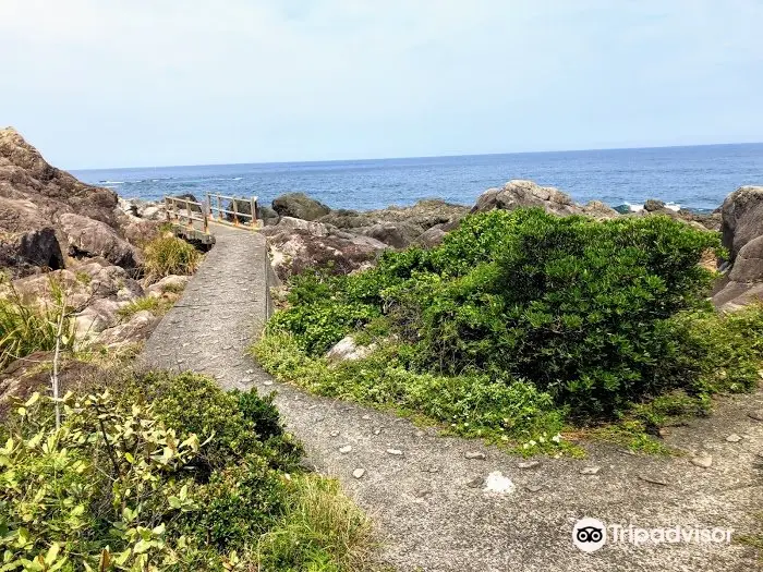
This Geopark is a popular sightseeing spot in Kochi, which is rich in nature. It is located at the tip of the Muroto Peninsula, and the site here continues to swell up to this day. In 2011, it was listed as one of the World Geoparks. The total area of Muroto Geopark in Muroto City is 248.20km2. In each region, you can come into contact with and learn about the history, living culture, and food culture that have coexisted with magnificent nature to this day. For example, Cape Hane was located on the bottom of the sea in ancient times, but now you can find trace fossils left by shellfish crawling on the rocky ground that was uplifted by earthquakes. On the Nishiyama Terrace of the Kira River, you can enjoy the scenery of various agricultural development using the sea steps of the uplifted terrain. Among them, the highlights of Muroto Cape are more concentrated. Here, you can walk along the walking path while admiring the rocks rising from the sea floor or subtropical plants. Visitors can also inquire about and take part in a walking tour of Cape Muroto accompanied by an English-speaking guide. If you want to experience Muroto Geopark to the fullest, first head to the Muroto Global Geopark Center. Here, you can learn about the origin, nature, history, and culture of Muroto land through videos and exhibitions. You can also collect tourist information at the information desk. Rental bicycles are also available, and it is highly recommended to take a bicycle tour of Muroto starting from the center. In addition, the official website also introduces recommended routes for tourists who can cruise alone.
Explore near Muroto Global Geopark Center: Where to Stay, Eat, and Visit
Muroto Global Geopark Center Reviews: Insider Insights and Visitor Experiences
Write a Review
 Trip.com(12 Reviews)TripAdvisor12 Reviews
Additional Information
You Might Also Like

Universal Studios Japan
10
4.8/518657 Reviews
From US$54.73
Umeda Sky Building
7.3
4.6/5794 Reviews
Save US$0.58
From US$9.08
Nijō Castle
7.7
4.6/51610 Reviews
From US$8.37
Osaka Castle Main Tower (Osaka Castle Museum)
7.2
4.6/51427 Reviews
From US$3.71
Nearby Attractions
Muroto Schoolhouse Aquarium | 室戸岬 | Muroto Dolphin Center | Shinshō Temple | Kongōchōji Temple | Mikuriyajin Cave | Kiramesse Muroto Whale Museum | Kiragawa Old Street | Yuhigaoka Campground | Statue of Young Kukai | Kitagawa village "Monet's Garden" Marmottan | Muroto Regional Park | Kanjogahama Beach | Tsukimigahama Beach | Muroto City Central Park | Raiei Temple | National park Cape Hane | Shintaro Nakaoka Museum | 日沖(ひおき) 丸山海岸 | Tanotano Onsen | The Statue of Shintaro Nakaoka | アコウの木 | Michi-no-Eki Kiramesse Muroto | Oka-Goten (Oka Palace and Museum Exhibition) | Mikurodo | Yasuda Education and Hospitaluty Center Nagomi | 佐喜浜八幡宮 | Lake Mearai | Myotoku-ji Temple | Muroto Haiko Aquarium
Popular Types of Attractions in Muroto
Parks | City Parks | Botanical Gardens | Amusement Parks | Religious Sites | Other Places of Worship | Temples | Churches and Cathedrals | Exhibition Centers | Museums | Art Museums | Art Galleries | Architecture & Landmarks | Monuments | landmark | Observation Decks | Historic Sites | Historical Sites | Castles | Cemeteries | Lifestyle | Hot Springs | Entertainment Centers | Libraries | Popular Spots | Nature | Attractions | Lakes | Mountains | Outdoor Sports
Popular Restaurants in Muroto
Shittoroto | Tosa | Geo Park Muroto | Minshuku Urashima | Miyabi | Drive-In Myotoiwa | Cafe Aloe | Kitchen Cafe Kaido | Tachi Sushi | Jibaumaya | Komaki | Cafe Mulzo | Henro no Eki Meotozenzai | Shokuyu Kujira no Sato | Izakaya Mangetsu | Sea Rest Muroto | Kurakukan Sakan | Ryotei Kagetsu | Ranman | Sakanamura | Cosmokun | Rapport | Reka | Kaisen Izakaya | Okonomiyaki Aki | European Style Restaurant Rucola | Kaidomuroto | Izakaya Takohachi | Ikkyu | Chikara
Popular Destinations
Jeddah Travel | Jinjiang Travel | Sihanoukville Travel | Sapporo Travel | Zhoushan Travel | Nice Travel | Barcelona Travel | Suzu Travel | Ningbo Travel | Mumbai Travel | Incheon Travel | Iligan Travel | Yangon Travel | Ulsan Travel | Port Klang Travel | Port Au Prince Travel | Bagan Travel | Gebze Travel | Kanhrawala Travel | Potrk Travel | Steuben Township Travel | Puerto Victoria Travel | Shakaman Travel | Purni Travel | Agharous Travel | Corrego Novo Travel | La Polka Travel | Klechovtse Travel
Recommended Attractions at Popular Destinations
Bangkok attraction near me | Tokyo attraction near me | Manila attraction near me | Hong Kong attraction near me | Taipei attraction near me | Seoul attraction near me | Los Angeles attraction near me | New York attraction near me | Shanghai attraction near me | Kuala Lumpur attraction near me | Shenzhen attraction near me | Osaka attraction near me | Singapore attraction near me | Guangzhou attraction near me | London attraction near me | San Francisco attraction near me | Beijing attraction near me | Macau attraction near me | Bali attraction near me | Paris attraction near me | Ho Chi Minh City attraction near me | Orlando attraction near me | Jakarta attraction near me | Phuket attraction near me | Chicago attraction near me | Toronto attraction near me | Istanbul attraction near me | Cebu attraction near me | Dallas attraction near me | Seattle attraction near me
More Things To Do in Muroto
Japan eSIM | SoftBank/IIJmio Unlimited 4G high-speed data(Natural day) | Asia 8 countries eSIM 4G high-speed network QR Code | Asia・Australia eSIM|AIS SIM2Fly 8 days 6GB High-speed Unlimited 5G/4G Data | Japan eSIM | Unlimited 4G High Speed Data (1 day = 24 hours) | Japan eSIM | Unlimited 5G high-speed data | Trip.SIM Japan, South Korea, Macau, Taiwan and many places in Asia + Australia and New Zealand 4G travel data roaming phone network card 4 days/7 days | Japan 4G SIM Card (HK, Macau, Taiwan, China Delivery Only) | Global multi-region A series eSIM|High-speed data, travel and business Internet access, optional unlimited data, optional days, QR code | Global Regions eSIM|Unlimited 4G High Speed Data | eSIM Japan by Gohub | [General in Asia] 4G network | Unlimited traffic | Self-pickup at the airport | WiFi rental, high-speed traffic, shared by multiple people, ready to use at boot, 12H standby, 24H customer service | 【Japan eSIM】Japan eSIM with Unlimited High-speed Data | [Unlimited Data] Japanese 4G/5G High-speed WiFi Sharer-Hong Kong Airport Pickup (Provided by WiFiBB) | Japan eSIM|High-speed data, travel and business Internet access, optional unlimited data, optional days, QR code | [Japan] 4G Internet Card|CMI|Unlimited Data SIM Card|Number of Optional Days|Insert the card and use it|Self-pickup at Hong Kong Airport | 1-Day Kochi Highlights Tour with local guide | Kochi Full-Day Private Trip with Government-Licensed Guide | Port Pick-Up: Kochi Tour with Licensed Guide and Vehicle | Japan eSIM High Speed Network Daily Data (QR Code) | Japan eSIM high-speed traffic, travel and business Internet, days optional softbank network QR code | Global multi-region C series eSIM|Common in 84 countries Travel and business Internet access Optional unlimited data Optional days QR code | Experience the energy of Kochi: Sunday Market Tour includes Kochi Castle | Iya Valley All Must-Sees Private Chauffeur Full-day Tour with a Driver | Japan eSIM Data Plan QR Code | Global multi-region B series eSIM|Universal in 54 countries Travel and business Internet access Optional unlimited data Optional days QR code | Global eSIM 4G/5G high-speed network QR code | Iya Valley BROMPTON Bicycle Tour | eSender - Japan eSIM daily package/data package (QR code) | Wakimachi BROMPTON Bicycle Tour | Global (30 Countries) eSIM Data Package (QR Code)
Payment Methods
Our Partners
Copyright © 2024 Trip.com Travel Singapore Pte. Ltd. All rights reserved
Site Operator: Trip.com Travel Singapore Pte. Ltd.
Site Operator: Trip.com Travel Singapore Pte. Ltd.
Kobo Daishi is full of land
The main purpose was to visit Sai Misakiji Temple, but when I looked at the sea side from the national highway on the coastline, I felt that it was a surprisingly steep coast with large rocks lined up. Also, when I looked over from the observatory of Cape Muroto Lighthouse, I was able to see the latest rough 々 waves, unlike looking down from the plane flying over the sky.
It's a geologically distinct place, and it's a UNESCO World Geopark.
The Muroto Peninsula is a geologically distinct place and is designated as UNESCO's World Geopark. I think it has more global characteristics than Japan's designation. Cape Muroto is a review other than that because there are independent items. There is a cape called Kaoka nose on National Highway 55 from Tokushima Airport to Cape Muroto, and there is a Meotoiwa in Kaoka. In addition, there are rocks where Tafoni looks beautiful. In addition, if you head toward Cape Muroto, you will find the Geopark Center. Going to Cape Muroto ...
terrain and unique lifestyle
Cape Muroto itself is not very touristy and is not woven, but it is interesting to look around. You can see the explanation of topographical geology at the Muroto UNESCO World Geopark Center. Cape Muroto is uplifted. Therefore, it is said that the Mikuriya cave, which Kukai practiced in this area, was once on the beach. And every time there is an earthquake, the harbor will rise and the harbor will be shallow, which seems to be difficult. Well ...
I went to the Geopark Center.
After sightseeing in Cape Muroto, I took a public bus to the Muroto World Geopark Center. In the hall, we introduce the state of the stratum of Cape Muroto and the footprints of Kobo Daishi. You can enter the museum for free.
Strange rocks born in submarine uplifts
Many strange rocks formed by uplifting the seabed at the end of the promenade near the statue of Shintaro Nakaoka along National Highway 55. On the way to the promenade, you can see a sardine tree that grows roots in the shape of holding a rock.