OverviewBookNearbyReviewsWin PrizesRecommended
Share to
Guozigou
果子溝5.1
238 Reviews
 based on 13 reviews
Open year round, 24/7
Recommended sightseeing time:2-3 hour
Address:
G30 Lianhuo Expy, Huocheng Xian, Yili Hasakezizhizhou, Xinjiang Weiwuerzizhiqu, ChinaMap
What travelers say:
Entering the fruit ditch, into the fairy tale fairyland, can not help but think about it. Leaving Sailimu Lake, boarding the pine tree, the whole world has a panoramic view, and the pine waves are in a state of mind. The road twists and turns, sometimes steep cliffs, sometimes like the abyss. Yunshan sent a burst of pine waves, wild fruit floated a fragrance. The clear spring suddenly left and right a wooden house, the room is hidden in the green leaves, floating on the grass. The adventure and beauty are gathered together, reality and dream are intertwined.
More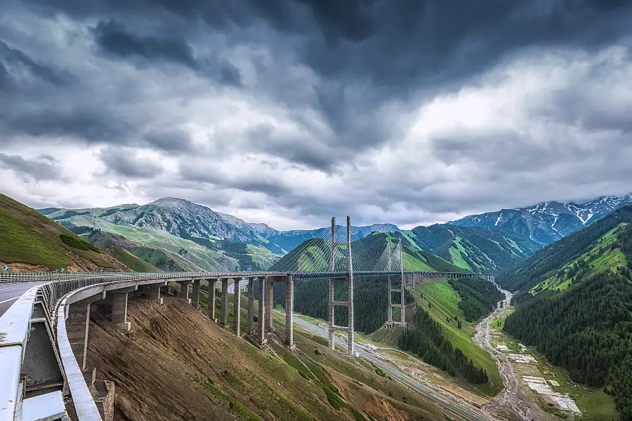
See all 37 photos
Saved by 10
Guozigou Highlights: Must-See Features and Attractions
Some information may have been translated by Google Translate
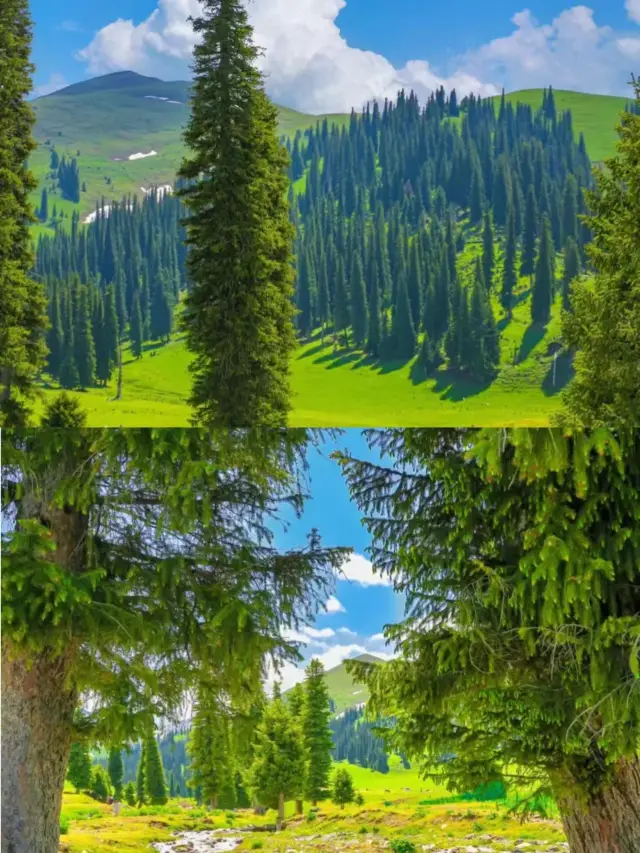
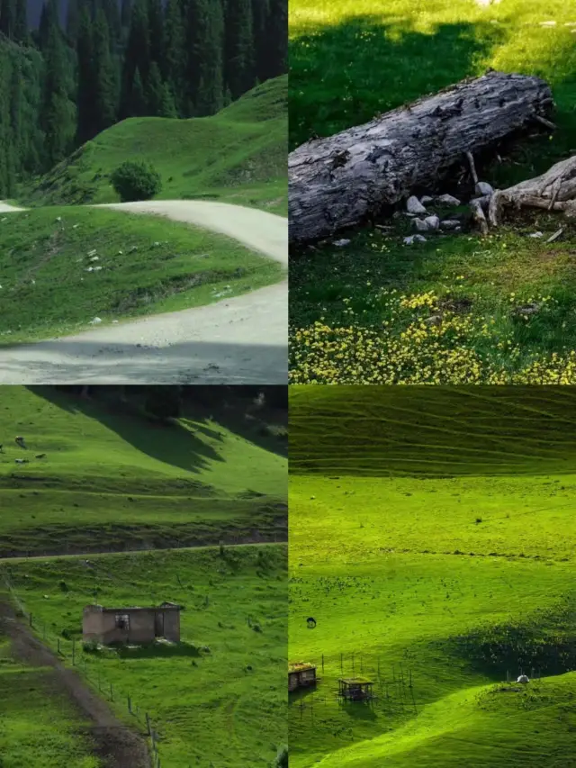
Guozigou is the natural gateway of the Ili area. It is a famous canyon tunnel that goes north to Sailimu Lake and south to Ili River Valley. In ancient times, it was the throat of my country's Silk Road North New Road leading to Central Asia and Europe, and it was called "Tieguan". At the same time, because of its pleasant scenery, it is known as "the first scene in Ili" and "the wonderland". The total length of Guozigou is 28 kilometers, and the terrain is dangerous. When Genghis Khan was on his westward expedition, he began to dig mountain passages and built 48 bridges, showing the steepness of the road. During the Qianlong period of the Qing Dynasty, it was rebuilt into 42 blocks, and it is still an important section of the Wuyi Highway. Although today’s Guozigou is no longer famous for its fruit trees, it still has beautiful scenery, with narrow valleys, strange rocks and rocks, towering peaks, luxuriant pines and birches, blooming mountain flowers, waterfalls and springs, and beautiful scenery. It is called the stunning scenery in the natural beauty. Guozigou is also a place full of mountain resources. The river beaches and hillsides of the entire valley are covered with wild Severus apples, mountain apricots and walnuts. This is where the name "Guozigou" comes from. In the early Yuan Dynasty, Yelu Chucai said in "Journey to the West" that Guozigou "the ground is all ringo, the trees are dark and the sun is not exposed". The Ringo here is the wild apple. Guozigou is a natural treasure house endowed by nature. It is not only distributed with vast fruit trees, but also rich in medicinal resources. Hare, fox, and wolves are often infested in the dense mountain forest.
Explore near Guozigou: Where to Stay, Eat, and Visit
Guozigou Reviews: Insider Insights and Visitor Experiences
Some reviews may have been translated by Google TranslateWrite a Review
 (238 Reviews)Trip.com(13 Reviews)TripAdvisor
/5
Outstanding ReviewsAll (238)
Latest
With Photos (183)
Positive Reviews (141)
- 1
- 2
- 3
- 4
- 48
Frequently Asked Questions About Guozigou
Guozigou Photos: Trip Moments
 Yili Luxury 5-Day TourXinjiang is the right way to cool off in summer. Summer is not just about air conditioning and watermelon, Come out and see the blue sky, white clouds, green pastures, and snow-white mountains Winding rivers, purple sea of flowers Come to Xinjiang to start a summer of 20°C .Get up and take a look at the stunning itinerary starting from Yining Day1: Yining City - Guozigou Bridge - Sayram Lake - Jinghe Day2: Jinghe - Dushanzi Grand Canyon - Duku Highway - Narat Day3: Narat Grassland - Qiaxi - Tekes Day4: Tekes - Qiongkushitai - Zhaosu Day5: Zhaosu - Xiat - YiningSLOAN MORAN
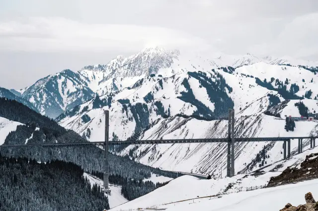 You must visit Guozigou after coming out of Sailimu LakeGuozigou in winter is also worth it Guozigou, known as the first scenic spot in Yili Has the highest bridge in Xinjiang, the Guozigou Bridge Overlooking the pure Tianshan snow-capped spruce The towering bridge is very spectacular Admire human wisdom and creativity Depart from the east gate of Sailimu Lake👉Play a counterclockwise circle from the south gate👉Turn right to Guozigou Go to Zhaosu after the wavediplomatic_leona
 The Pearl of Ili: The Beautiful Journey of Guozigou BridgeIn Ili, there is a place known as the "first scene", that is the Guozigou Bridge. It is like a long dragon, crossing about 28 kilometers of canyon, showing magnificent scenery. This canyon, named after the wild apples in the mountains, its beauty can only be truly appreciated when you are there. Guozigou Bridge is not just a bridge, it is actually a scenic line composed of three parts: Guozigou Scenic Area, Guozigou Bridge Deck Scenery and Guozigou Canyon Scenery. Each part has its unique charm, waiting for you to explore and discover. Guozigou Scenic Area, like a natural scroll, shows the magnificent and peculiar Xinjiang. The landscape here has always been regarded as a famous place in Xinjiang, its beauty and mystery have earned it the title of "the first scene of Ili". Standing here, you can feel the magic and power of nature. And when you stand on the Guozigou Bridge, overlooking the entire canyon scenery, you will see a different picture. Looking down from a high place, the road in the canyon is like a long dragon, winding between the mountains, forming a beautiful picture with the distant snow-capped mountains and blue sky and white clouds. Here, you can feel the grandeur and majesty of nature. If you are lucky, you can also see the sunset clouds in the evening, or admire the brilliant starry sky at night. These beautiful scenes are the best time to shoot, I believe you will definitely leave beautiful memories here. In addition, Guozigou is also a very suitable place for shooting. If you are interested, you can rent a horse here, ride it through the valley, and feel the beauty and tranquility of nature. This is also a place where many newlyweds choose to take wedding photos, because the scenery here is really beautiful. In general, Guozigou Bridge is a place worth exploring and experiencing. Its beauty and mystery will definitely leave a deep impression on you. If you have the opportunity to come to Ili, don't miss this beautiful place.OWEN BOYD1
 Xinjiang tourism, must-know strategy!Xinjiang is a travel dream that every tourist must reach. After all, Xinjiang has different scenery in all four seasons, but they can all give you different surprises! If you want to travel to Xinjiang but don't know how to plan your itinerary, then you must bookmark this note! Xinjiang has a unique geographical feature of "three mountains and two basins", with peculiar natural landscapes, profound historical and cultural heritage, rich cultural relics and ethnic customs. Tianshan Mountain is a magical boundary line that divides Xinjiang into Southern and Northern Xinjiang. Northern Xinjiang focuses on humanities, while Southern Xinjiang focuses on natural scenery, with completely different styles on both sides. In southern Xinjiang, there are many deserts, while in northern Xinjiang, there are vast grasslands, and the lifestyles of the people on both sides are very different. Of course, the natural scenery in southern Xinjiang is also very impressive, with deserts and poplar trees being extremely magnificent, but the overall natural resources cannot be compared with those in northern Xinjiang. Due to its vast grasslands, Northern Xinjiang boasts spectacular natural scenery. In addition to the division between Southern and Northern Xinjiang, there is also the Yili-Korla line. Yili can be considered the scenic ceiling of the entire region, with several top attractions such as Sayram Lake, the Lati Grasslands, Apricot Valley, and Guozigou all gathered in Yili. Korla Line refers to Urumqi and its surrounding areas, where popular places such as Grand Bazaar, Tianshan Mountains, Heavenly Lake, Turpan, Bayinbuluke are located. And the famous Duku Highway connects the north and south of Xinjiang. It crosses the Tianshan Mountains with 608 180-degree folded bends, and even 270-degree bends. What is the best time to visit Northern Xinjiang? Northern Xinjiang is suitable for traveling from June to September. The weather is relatively cool in summer, and the scenery is also very good, making it the first choice for self-driving enthusiasts. Different months offer different experiences, such as flower seas, grasslands, and snowscapes. Southern Xinjiang is actually suitable for travel all year round, with the best time being from July to October. Xinjiang, how to choose the route? There are many routes for traveling in Xinjiang, but for those who are visiting for the first or second time, exploring these three basic routes can allow you to experience most of the highlights of Xinjiang. If time and money permit, and you have a strong interest, it is recommended that you visit them all. Route 1. Yili-Duku Highway The best route for working people to take a 7-day vacation. Route 2. Kanas Small Loop Autumn viewing must-go itinerary 7-9 days Route 3. Northern Xinjiang Grand Loop Kanas + Yili + Duku Highway, suitable for people who can have a long vacation to have fun for 12-15 days.uppergave3
 Today we came to the fruit ditch with the "Ili first scene" to see what is unique here. We did not enter the fruit ditch scenic area, only overlooking the fruit ditch scenery at the high point, and of course the fruit ditch bridge that can not be missed. When viewing the panorama through the drone, the field of vision magnifies the beauty of the fruit ditch. First of all, we can see that the relationship between the fruit ditch and Sailimu Lake is actually separated by a mountain. Therefore, friends who come to Sailimu Lake must pack the fruit ditch together. Because of the mountains and the water, this is two completely different landscape modes. On the side of the fruit ditch, you need to experience the snow mountain, the green trees and green hills, the green hills, such as the dragon's gully, very spectacular! If you look at the fruit ditch online, all the literature will mention that the terrain is dangerous, and it is the throat of the North Road to Silk Road in Central Asia and Europe. Genghis Khan once built a bridge of 48 here because it was too dangerous. Even after the Qing Emperor Qianlong was built into 42 blocks. These words all indicate that bridges have been an important component of the fruit ditch since ancient times. The same is true nowadays. When you come to the fruit ditch tour, you will definitely take a group of photos for the Guogou Bridge that opened in 2011. Because it is not only the logo of the fruit ditch, it is also an important traffic masterpiece. We can see that between the stretch of the hillside, a road is like a blood vessel, connecting every hill. Some are built around the mountains, and some are built directly by making holes in the mountains. As the saying goes, I want to get rich and build roads. From the air, I can't help but feel the prosperity of the country. It is self-evident that such a mountain road can be built in such a natural danger. But as long as it is made, it must be shocking. If you drive the fruit ditch, you can drive from these roads, green hills on both sides, and snow mountains in the distance. It is no wonder that many people will sigh "Where you come to Xinjiang, and what Switzerland to go to!" The sunset glow of the fruit ditch is also beautiful. Because we were on the road, we did not carefully record, but listened to the locals, the probability of a sunset glow in the fruit ditch is very high. Therefore, it is recommended that friends who like photography can consider staying in the fruit ditch for a night, maybe they will encounter a rare fire in the city, look forward to expecting!Mr_Huang_.
 The Cabin of the Fruit Ditch | After the Saimu Lake, we lived in a beautifully dreamy forest log cabin, located in the Guogougou National Forest Park. Another name of the fruit ditch is Talqida, which is called Ili First Scene. It is located 40km northeast of Huocheng County, and is the must of Urumqi-Ili Highway on National Highway 312. The channel, the northern end of the ditch is the famous Lake Selim. The fruit ditch is 28km long and has a high mountain and is covered with tall silver fir. Bishan surrounds, Zhong Ling Xiu Xiu, as if in Switzerland, here can satisfy all my beautiful fantasy of the forest cabin. Each cabin is equivalent to a small villa with four rooms and a living room for four people. And for dinner we ate the game that we couldn't eat, the fish in Saihu, and one kilogram of three thousand morel.Moer.
 The 28-kilometer long fruit ditch is a canyon that connects the Sailimu Lake and the Ili Valley. It is the throat of the Silk Road North New Road to Central Asia and Europe in ancient times. It is named as a fruit because the valley is covered with wild fruit trees. ditch. When the sun shines on the whole fruit ditch, the cold morning begins to warm up, and the big brother of Zema looks like a hero, and the feeling of riding is not as good as the imagination, exciting and thrilling. There is a kind of The feeling that the bones want to fall apart but wants to stop can still add a kind of endless pleasure to the fruit ditch in the early morning. I have climbed so many mountains, walked through so many roads, walked so many bridges, the mountains of the fruit ditch, the road of the fruit ditch, the bridge of the fruit ditch, the early morning of the fruit ditch, the fruit ditch At night, I often remember, with thoughts and laughter.kaixincaicai.
 The Horgos Port, here, is an important station on the northern road of Gusi Road in the Sui and Tang Dynasties. If you want to go to the border port and need to bring your passport, you can directly pull it, no need to pay another 15 yuan for a visa. Before going to Horgos, we have to pass a very famous bridge, the Yogurt Bridge. Fruit ditch is the natural gateway of Yili area. It is a famous canyon hole in the north of Sailimu Lake and the Ili Valley in the south. The fruit ditch is 28 kilometers in length. The terrain is dangerous. When the Genghis Khan is in the west, the mountain channel is built. 48 bridges, the road is steep. We drive along the Wuyi Highway and pass through the fruit ditch. If we go from east to west, we will pass through the famous Sailimu Lake and then reach the fruit ditch through a few kilometers of mountain tunnel. The bridge has strength and grace, and the spectacular S bends around the valley. At this time, open the window and feel the scenery. Entering Yili, there are many pine trees and all kinds of wild flowers and fruit trees in the mountains. In summer, cattle and sheep patrol the mountains, and pastoralists and yurts can be seen everywhere. There are also some beekeepers scattered in the mountains. The pure wildflower honey is produced here!misstuanzi.
Nearby Attractions
Huocheng Lavender Fields | Princess Jieyou's Lavender Garden | Open desert | Huiyuan Ancient City | 伊犁河谷國家濕地公園 | Yilijiangjunfu Ruins | 解憂公主薰衣草農場 | Qingshuihe Town | Lavender garden | 小馬薰衣草莊園 | Han Princess Marsh Lavender | 錫伯古城景區 | 漫心忘憂谷 | Museum of Frontier Defense History | Kekdala travel Caoyuanzhiye style Park | Ayiduo Xunyicao Culture Tourism Sceneic Area | Kuailexing Ski Field | Xibo National Museum | Jingyuan Temple | Yili General Mansion | 伊寧市象鼻山 | China National Museum Qapqal Branch | Dameixiyu Ski Field | 伊力特酒文化產業園 | 人民大會堂 | 朱雀湖公園 | 梅嫂農家樂 | 錫伯古城·時光隧道 | Yili Siluhua Dou Ying Garden | Yuejin No.3 Reservoir
Popular Types of Attractions in Huocheng
Nature | Grasslands | Mountains | Flower Fields | Architecture & Landmarks | Featured Neighborhoods | landmark | Monuments | Exhibition Centers | Exhibition Halls | Museums | Memorial Halls | Lifestyle | Campgrounds | Libraries | Agritourism | Traditional/Cultural Experiences | Villages | Farms | Parks | Botanical Gardens | City Parks | Historic Sites | Sports | Outdoor Sports
Popular Restaurants in Huocheng
晃晃咖啡 | SI SHI JIU WAN ZI SHANG | 顺风123 | JIN PAI MEI WEI ZA SUI WANG | 金麦粒鲜奶蛋糕店 | 老1号美味羊杂鼎食之家 | 50艳妹美味居羊杂餐厅 | 阿舍凉粉(霍城店) | 伊犁杂碎美食城 | 霍城云升酒店·中餐厅 | 金家大院农家乐 | 疆味楼兰姑娘 | 常相聚农家乐 | 弗瑞德主题餐厅 | 巴伊烧烤 | 飘香村农家庭院 | 现捞辣卤 | 伊和兄弟烤吧(紫金名门店) | 椒尚椒新疆良汤火锅(清水河店) | 聚轩烧烤手抓肉 | 凝蜀香川菜馆 | Grabbing hotel | 麻辣盛宴肥牛火锅(团结路店) | 88芦草沟老美味杂碎店 | CHAN SI MAO LU ZHU TI | 鑫辉烧烤(幸福路店) | 疯狂薯条(清水河店) | 第一家手擀面 | YI YANG GA FEI XI CAN TING | 迈德堡清真汉堡连锁(霍城店)
Popular Destinations
Guangdong Travel | Okinawa Travel | Abu Dhabi Travel | Vancouver Travel | Quezon City Travel | Zaandam Travel | Zhengzhou Travel | Ulanqab Travel | Jongno-gu Travel | Sanya Travel | Dubai Travel | Baglung Travel | Phuket Travel | Jiangxi Travel | Seogwipo Travel | Tada Travel | Pekanbaru Travel | Dengkil Travel | Newton and Noss Travel | Huta-Studenets'ka Travel | Yang Tha Chang Travel | Itutinga Travel | Bhusni Travel | TT. Neo Travel | Mereti Travel | Alfredo Marcondes Travel | Sturt Vale Travel | Ayam Travel
Recommended Attractions at Popular Destinations
Bangkok attraction near me | Tokyo attraction near me | Manila attraction near me | Hong Kong attraction near me | Taipei attraction near me | Seoul attraction near me | Los Angeles attraction near me | New York attraction near me | Shanghai attraction near me | Kuala Lumpur attraction near me | Shenzhen attraction near me | Osaka attraction near me | Singapore attraction near me | London attraction near me | Guangzhou attraction near me | San Francisco attraction near me | Beijing attraction near me | Macau attraction near me | Bali attraction near me | Paris attraction near me | Ho Chi Minh City attraction near me | Orlando attraction near me | Jakarta attraction near me | Chicago attraction near me | Phuket attraction near me | Toronto attraction near me | Istanbul attraction near me | Dallas attraction near me | Cebu attraction near me | Seattle attraction near me
Popular Trip Moments
Don't leave after seeing Sayram Lake! Make a detour to check out this 'architectural wonder' | May Day Xinjiang Travel | Yili Loop 7-Day Attractions + Itinerary Guide | April in Yili is like heaven on earth, with flowers blooming along the way | A 5-day tour of Northern Xinjiang | Xinjiang Travel Guide | Xinjiang is not as far as imagined, but it's great for photography | Yili Luxury 5-Day Tour | May Xinjiang Yili Loop Tour | Grasslands, Flower Seas, Snow Mountains, Cattle and Sheep | More beautiful than Japanese cherry blossoms! Featured on 'China National Geographic' for its stunning beauty | The golden passage of the ancient Silk Road North Road | You must visit Guozigou after coming out of Sailimu Lake | The Pearl of Ili: The Beautiful Journey of Guozigou Bridge | Lavender Sea This is not Provence, it's Yili, Xinjiang | The ultimate guide to enjoying the blue ice of Sailimu Lake | Check in at the lavender garden | Ili River Scenic Area, can only be described with two simplest words, great beauty | Sailimu Lake + Guozigou Bridge = Dreamy linkage | It's hard to imagine that this is Yili in the middle of October | Worry-free Princess*Lavender Garden | Xinjiang Ten-Day Tour Guide | Xinjiang tourism, must-know strategy! | Xinjiang Guozigou Bridge | The Bridge of Life on the Tianqian Plateau and Guozigou Waterfall
More Things To Do in Huocheng
8-Day Urumqi to Yining Private Tour Included Sayram Lake, lavender vistas. Kuokesu Canyon | China eSIM Day Pass/data Package days selected without cards QR code | China·Hong Kong·Macau eSIM|Unlimited 4G High-speed Data | China Mainland eSIM|China Mobile Unlimited 4G High Speed Data | China, Hong Kong, and Macau eSIM|Total 5GB/10GB/15GB/20GB High-speed 4G LTE Unlimited high-speed data | Mainland China eSIM |China Mobile 4G high-speed unlimited data eSIM | Asia・Australia eSIM|AIS SIM2Fly 8 days 6GB High-speed Unlimited 5G/4G Data | [China Mainland] eSIM | SIM to China | 8GB 8days 4G high speed | Mainland China + Hong Kong + Macau eSIM 4G Data Daily Plan QR Code | Trip.SIM Japan, South Korea, Macau, Taiwan and many places in Asia + Australia and New Zealand 4G travel data roaming phone network card 4 days/7 days | eSender - Mainland China eSIM daily package/traffic package, days optional. No need to get the card QR code | [China, Hong Kong and Macau] 4G network | Unlimited traffic | Self-pickup at the airport | WiFi rental, high-speed traffic, shared by multiple people, ready to use at startup, 12H standby, 24H customer service | Mainland China + Hong Kong + Macau eSIM Data Plan QR Code | China, Hong Kong, Macau 4G SIM Card (HK, Macau, Taiwan, China Delivery Only) | Global multi-region A series eSIM|High-speed data, travel and business Internet access, optional unlimited data, optional days, QR code | [Hong Kong, Mainland China] 4G Internet Card | China Unicom/Hutchison | Unlimited data SIM card | Optional days | Insert the card and use | Self-pickup at Hong Kong Airport | China, Hong Kong, Macau eSim 1/3/7/15/30 days (sent via email) by Xplori | [Mainland China, Hong Kong and Macau] 4G Internet Card|China Unicom/Hutchison/CTM|Unlimited data SIM card|Number of optional days|Insert the card and use|Self-pickup at Hong Kong Airport | China/Hong Kong/Macau eSIM 4G high-speed network QR code | AIS Global esim data package (QR code) | eSIM for China, Hong Kong and Macau. Universal for Mainland China/Hong Kong/Macau. Optional days for travel and business. QR code | 【5G SIM Card】China・National 5G Universal SIM Card |Total 10GB/15GB/30GB/45GB High-speed 5G Unlimited Data Service (Pick up at Shanghai Pudong T2) | [FLASH SALE] China, Hong Kong, Macau eSIM - Data plan by Gohub (QR Code) | AIS SIM2Fly Global eSIM|15 days 6GB high-speed 4G/5G Unlimited Data | Global (30 Countries) eSIM Data Package (QR Code) | Mainland China eSIM high-speed network QR code | Global multi-region B series eSIM|Universal in 54 countries Travel and business Internet access Optional unlimited data Optional days QR code | AIS Asia esim data package (QR code) | [Mainland China] 4G Internet Card|China Unicom|Unlimited Data SIM Card|Number of Optional Days|Insert the card and use it|Self-pickup at Hong Kong Airport | Global multi-region C series eSIM|Common in 84 countries Travel and business Internet access Optional unlimited data Optional days QR code
Payment Methods
Our Partners
Copyright © 2024 Trip.com Travel Singapore Pte. Ltd. All rights reserved
Site Operator: Trip.com Travel Singapore Pte. Ltd.
Site Operator: Trip.com Travel Singapore Pte. Ltd.
Entering the fruit ditch, into the fairy tale fairyland, can not help but think about it. Leaving Sailimu Lake, boarding the pine tree, the whole world has a panoramic view, and the pine waves are in a state of mind. The road twists and turns, sometimes steep cliffs, sometimes like the abyss. Yunshan sent a burst of pine waves, wild fruit floated a fragrance. The clear spring suddenly left and right a wooden house, the room is hidden in the green leaves, floating on the grass. The adventure and beauty are gathered together, reality and dream are intertwined.
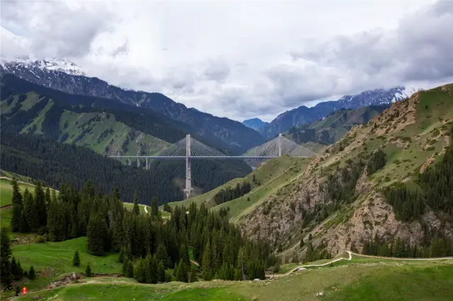
Guozigou Bridge is a high-speed passageway in Xinjiang Uygur Autonomous Region, China. It is located on the Guozigou Canyon. It is one of the main components of Lianyungang-Horgos Expressway. It starts from Mengqiongkule in the north, crosses the Guozigou Canyon in the south and the Generalgou Tunnel in the south. The full length of the line is 4.4 kilometers, and the bridge is 700 meters long.
Guozigou Bridge starts from Mengqiongkule in the north, crosses the Guozigou Canyon, and goes south to the Generalgou Tunnel; the line is4.4 kilometers long, and the bridge is 700 meters long; the bridge is a two-way four-lane expressway, and the design speed is 80 kilometers/hour.
Guozigou is the natural gateway of Yili area, is a famous Canyon passageway that goes north to the Sailimu Lake and south to the Yili River Valley. In ancient times, this is the throat of the new Silk Road North to Central Asia and Europe, which is called Tieguan. At the same time, because of its pleasant scenery, it is praised as "the first scenery of Yili", "fantastic fairyland". Ancient poets praise its "the wonder of mountains and rivalleys, as strange as Guilin and cliffs and rocks. It's better than Yanyan. Guozigou is 28 kilometers long and the terrain is very dangerous. When Genghis Khan took the Western Expedition, he began to dig the mountain passage and built 48 bridges, which shows the steep road. During the Qianlong reign of the Qing Dynasty, 42 roads were rebuilt, and they are still important sections of the main line of the Uyi Highway. Guozigou is located 40 kilometers northeast of Huocheng County, Yili, Xinjiang. It is a famous Canyon channel which goes north to the Sailimu Lake and south to the Yili Valley. Its total length is 28 kilometers. This ditch is the throat of the Silk Road North New Road to Central Asia and Europe in ancient China, and now passes through 312 National Road. The river beach and hillside of the whole valley are full of wild Savi apples and apricots, walnuts and "fruit ditch" which is the name of it. In the dense mountain forests, there are many wild animals and birds, such as rabbits, foxes, wolves, bears, wild boars, red deer and so on, forming a very elegant natural zoo.
Guozigou was first read about it, which was written by Shepperzan in his middle school textbook. Today, Guozigou Bridge is more famous here at home and abroad. But the old road mentioned in the middle school textbooks has undoubtedly become a perfect place to appreciate the Guozigou Bridge, but few people go to see it. By the time we went, the old road had been semi-closed and there was a door to collect tickets.
Guozigou is located in Huocheng County, Ili Prefecture. It is an important passageway connecting Ili and Bole. It is also a bridgehead leading to the west of China's coastal areas. From here, it can reach the port of Horgos quickly and leave Kazakhstan. Fruit ditch is a natural barrier, overlapping mountains and shading the sun. Here is the typical scenery of northern Xinjiang. The spruce and pine trees on the hillside were arranged in neat rows, like tall sentinels. The mountains are rocky and steep. There is a kind of cold light in the sunshine, which makes people palpitate. The most beautiful view of Guozigou is not the natural scenery, but the Guozigou Bridge. As high as hundreds of meters, like an overpass, the whole body is high-speed railway. It takes thirty or forty minutes to walk over the bridge and then over it. Guozigou Bridge is a 360 degree viewing platform with infinite scenery. Unfortunately, we can't Park here. Out of the Guozigou Bridge Cave is the famous Sailimu Lake. When I heard the sound of water, I saw a blue sea. On the opposite side of the lake is the grassland, where sporadic Kazakhs live, and there are carpet houses unique to the Kazakhs.