軍山湖
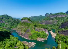
It turned out that there was more than one water road in Jiangxi | with aerial photography point ||| Key points: Junshan Lake (Jinxi Lake) Jinxian County, Nanchang City 🚨 Once on the way back to Nanchang from Sanqing Mountain, I found that the high-speed sunset was very beautiful, so I recorded the location. This time, I searched for nearby locations. Found some spots suitable for aerial photography and sunset viewing. 🚨 The water sunset section is located on the Jinxi Lake Bridge. Jinxi Lake and Junshan Lake are actually a piece of water connected together. Since Jinxi Lake Bridge is a highway bridge, I chose [Caomen Village] near the bridge as the take-off point for drones. There are some open lake areas in the village. Since the local area is not a scenic spot, please pay attention to environmental sanitation and do not affect others. 🚨 Secondly, the better-looking pastoral scenery in the video, the take-off point I chose is a small road near the Hangzhou-Changzhou Expressway, called [Turning Section], the small road will go north to the embankment, and the drone taking off from here can take a beautiful village scenery. I like to photograph the yellow scorpion breeding area of local villagers most: the picture of farmers sitting on the water is very interesting, against the backdrop of the reflection of the water. 🚨 In addition, I found a highway line that can take a beautiful sunset, and the co-pilot can take a video of sunset birds and distant wire towers with a cloud platform extension pole in the car. This road is called Changwan Highway. I will set the starting point at [Sanli Bus Terminal] and the end point is [Sinopec Jinxian Junshan Lake gas station]. Driving along Changwan Highway, this direction is towards the sunset at sunset, it is worth a try.
MoreExplore near 軍山湖: Where to Stay, Eat, and Visit
軍山湖 Reviews: Insider Insights and Visitor Experiences
Some reviews may have been translated by Google TranslateYou Might Also Like

山貓王國親子運動樂園
Wuyishan National Park

Pingxiang Wugong Mountain Scenic Area
Lushan Taohuayuan Scenic Area
Nearby Attractions
Popular Types of Attractions in Jinxian
Popular Restaurants in Jinxian
Popular Destinations
Recommended Attractions at Popular Destinations
More Things To Do in Jinxian
Site Operator: Trip.com Travel Singapore Pte. Ltd.
It turned out that there was more than one water road in Jiangxi | with aerial photography point ||| Key points: Junshan Lake (Jinxi Lake) Jinxian County, Nanchang City 🚨 Once on the way back to Nanchang from Sanqing Mountain, I found that the high-speed sunset was very beautiful, so I recorded the location. This time, I searched for nearby locations. Found some spots suitable for aerial photography and sunset viewing. 🚨 The water sunset section is located on the Jinxi Lake Bridge. Jinxi Lake and Junshan Lake are actually a piece of water connected together. Since Jinxi Lake Bridge is a highway bridge, I chose [Caomen Village] near the bridge as the take-off point for drones. There are some open lake areas in the village. Since the local area is not a scenic spot, please pay attention to environmental sanitation and do not affect others. 🚨 Secondly, the better-looking pastoral scenery in the video, the take-off point I chose is a small road near the Hangzhou-Changzhou Expressway, called [Turning Section], the small road will go north to the embankment, and the drone taking off from here can take a beautiful village scenery. I like to photograph the yellow scorpion breeding area of local villagers most: the picture of farmers sitting on the water is very interesting, against the backdrop of the reflection of the water. 🚨 In addition, I found a highway line that can take a beautiful sunset, and the co-pilot can take a video of sunset birds and distant wire towers with a cloud platform extension pole in the car. This road is called Changwan Highway. I will set the starting point at [Sanli Bus Terminal] and the end point is [Sinopec Jinxian Junshan Lake gas station]. Driving along Changwan Highway, this direction is towards the sunset at sunset, it is worth a try.