


1 / 9
Mentioned in This Moment
Weixi
View
Show More
Life advice: You must visit Antarctica at least once
EthanHenderson59
I lost my heart after a trip to Antarctica Luo
AMBROSE SOTO
Yunnan's Nanji Luo
MALEAH LEE
Explore the 'Tears of God Lost in the Human World'
JAZMINE SIMMONS
Yunnan's Last Secret Realm: Nanyi Luoluo
amara_hawkwood_95
Yunnan's Hidden Gem: The Journey to Nanji Luo
FIONA BRADLEY
Popular Trip Moments
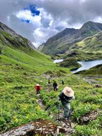
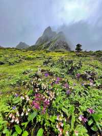
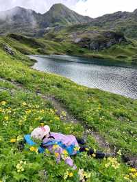
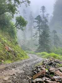
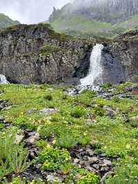
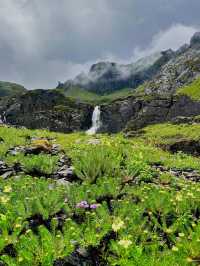
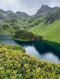
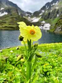
Life advice: You must visit Antarctica at least once | I lost my heart after a trip to Antarctica Luo | The May Day plan is to head straight to Nanjiluo in Antarctica, it's so beautiful here | Yunnan's Nanji Luo | This place is truly not abroad; they say it is God's own backyard | Explore the 'Tears of God Lost in the Human World' | Antarctic Luo Trekking | A meeting with snow and scenery | Yunnan's hidden gem! Come and explore it with us! | Yunnan's Last Secret Realm: Nanyi Luoluo | An ancient village unknown to 99% of people | Tongle Village, Shangri-La, Yunnan | 2024 Winter Vacation Yunnan! | Nanjiluo is now open, and it's very stable this year! Don't miss the flowering season in June | Yunnan's Hidden Gem: The Journey to Nanji Luo | You're crazy! I didn't go abroad! It's Nanji Luo! | Antarctica Luo | Stay away from the crowd, go listen to the wind in the wilderness | High-altitude Lake Cluster: A Hidden Spectacular Sight in Yunnan | Explore the southern Antelope in Yunnan and encounter a stunning secret realm, appreciating the wonders of nature | How beautiful is the summer in Antarctica Luo | Travel essentials guide | These are 9 niche attractions I have visited. | In this life, I must travel to Nange Luo in the Antarctic, where the hidden routes are as if one is in Europe! | Antarctic Luo|For the first time in my life, high-altitude trekking brought me to tears | The Princess and Prince's hiking journey through the fairyland of Antarctica Luo awaits your attendance | Explore Nanjiluo, the most comprehensive guide is here! | Shangri-La, feel the shock brought by another world, the voice of the soul is called | Antarctic Luo | Feel the sacred mountain and lake in your heart | The end of the world is a snowy mountain | Antarctic Luo Travel Guide | Antarctic Luo hiking guide | Don't go where it's crowded, find a quiet place | I'm so great~ Challenge the journey to niche secret places!
Popular Destinations
Munich Travel | Türkiye Travel | Lisbon Travel | Jinjiang Travel | Sihanoukville Travel | Sapporo Travel | Phu Quoc Island Travel | Nice Travel | Barcelona Travel | Suzu Travel | Maha Chana Chai District Travel | Tagum Travel | Incheon Travel | Las Palmas de Arriba Travel | Saudi Arabia Travel | Prague Travel | Singkawang Travel | Ishigaki Travel | Puerto Victoria Travel | Shakaman Travel | Purni Travel | Agharous Travel | Corrego Novo Travel | La Polka Travel | Baddi Travel | Mangwadgaon Travel | Amble Travel | Talagskiy Gorodok Travel
Recommended Attractions at Popular Destinations
Bangkok attraction near me | Tokyo attraction near me | Manila attraction near me | Hong Kong attraction near me | Seoul attraction near me | Taipei attraction near me | Los Angeles attraction near me | New York attraction near me | Shanghai attraction near me | Kuala Lumpur attraction near me | Shenzhen attraction near me | Osaka attraction near me | London attraction near me | Singapore attraction near me | Guangzhou attraction near me | San Francisco attraction near me | Beijing attraction near me | Macau attraction near me | Bali attraction near me | Paris attraction near me | Orlando attraction near me | Jakarta attraction near me | Ho Chi Minh City attraction near me | Chicago attraction near me | Phuket attraction near me | Toronto attraction near me | Dallas attraction near me | Istanbul attraction near me | Cebu attraction near me | Seattle attraction near me
Popular Attractions
Burj Khalifa | Chengdu Du Fu Thatched Cottage Museum | Beijing World Park | Chengdu Research Base of Giant Panda Breeding | Sunway Lagoon Theme Park | Shanghai Museum | Statue of Liberty | Gankeng Hakka Town | Dujiangyan Irrigation System | Beijing Wildlife Park | Hong Kong Disneyland | Paris Ferris Wheel | Baishuizhai Scenic Area | Zhangjiajie Grand Canyon Glass Bridge | Snow Park | Marina Bay Sands | Jingshan Park | Alison Lester Gallery | Badega Gunung Parang | The Longwood Center for the Visual Arts | Intersport La Godille | Cultural Plaza | Parco Faunistico Pianpinedo | Excursiones ECO, Inc. | Zhuti Ancient Town | General Post Office (G.P.O.) | Oyster Boat Terror | VinWonders Phu Quoc | Shenzhen Ping An Financial Center Yunji Sightseeing | Universal Studios Hollywood
Popular Restaurants in Weixi
天海酒家 | Yanwa Braised Chicken | 滇金丝猴国家公园专家别苑·阁之米 | 大理喜洲回族饭店 | 维西漫寻记的家庭院别墅·漫寻记别院餐厅 | 蓝鸟酒吧 | BI LAI KE | 蜀大侠火锅(维西店) | 怡和庄园 | 田园阁农家乐 | 青莎金花鱼庄 | 鸳鸯蛙火锅 | 草墩屋火锅正宗海稍鱼(香维线店) | 大理魏山风味园 | 鹿格餐厅 | YIKIYIKI馆 | 巍山清真伊香牛肉馆 | 三锅庄 | 山货小馆 | 上锦宴鲜毛肚火锅 | 维西老面瘦肉灌汤包 | 腊普生态鱼庄 | 桂林米线烧烤 | 老街 | 永胜饭庄 | 德胜桥豆花米线(维西店) | 邓川蝶泉牛奶(总店) | 茈碧湖鱼庄 | 广聚楼 | Wangjiaoshishangfengkuangkaochi
Payment Methods
Our Partners
Copyright © 2024 Trip.com Travel Singapore Pte. Ltd. All rights reserved
Site Operator: Trip.com Travel Singapore Pte. Ltd.
Site Operator: Trip.com Travel Singapore Pte. Ltd.