OverviewBookNearbyReviewsWin PrizesRecommended
Share to
Shidao Island
石島3.0
12 Reviews
Recommended sightseeing time:5 hour
Address:
Shidao Island, Xisha IslandsMap
What travelers say:
It's not big here, it's only a few hundred square meters, there is a Xisha old dragon head and a boundary monument. It is connected to a road from Yongxing Island. Watching the waves on Shidao, the scenery is still beautiful. If you have a fate, you can go to Xisha and turn around. 15 minutes is enough.
More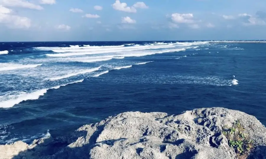
See 1 photo
Saved by 1
Shidao Island Highlights: Must-See Features and Attractions
Some information may have been translated by Google Translate
Shidao is a higher island among the islands in the South China Sea, with an altitude of 13 meters above sea level. The whole stone bird is not like Yongxing Island at all, there are no tall trees, only grass and thorns. It is also different from other islands in Xisha, it is not composed of coral woods, its composition is reefs, the reefs here are of various shapes and have high ornamental value. The blue water, white waves, moist sea breeze, and rushing waves constitute a natural picture of the island in the south. Shidao and Yongxing Island and Yongxing Island are located on the same reef. The two islands can be waded between the two islands at low tide. There is a nearly 200-meter-long cement bridge in the middle. Both sides of the bridge are as clear as mirrors. Shallow sea. Walking through the stone bridge, you can see a coral reef several feet high, which is the gate of Shidao. Because the stone island is as high as 15.9 meters, it is a useful lookout point in Xuande Atoll. It can observe ships coming and going on the east and west seas, like a bridgehead fortress on Yongxing Island, which is very important in military affairs. In addition, in the shallow sea in the southwest of Yongxing Island, there are a group of submerged beach reefs. The beach extends from northwest to southeast, and the water depth is about 14 meters. It is the main beach reef that constitutes the south wing of Xuande Ring.
Explore near Shidao Island: Where to Stay, Eat, and Visit
Shidao Island Reviews: Insider Insights and Visitor Experiences
Some reviews may have been translated by Google TranslateWrite a Review
/5
Outstanding ReviewsAll (12)
Latest
With Photos (4)
Positive Reviews (10)
- 1
- 2
- 3
Frequently Asked Questions About Shidao Island
You Might Also Like
Boundary Island
8.8
4.5/510213 Reviews
Save US$1.24
From US$16.29

Dazhou Island
5.8
4.8/5253 Reviews
Free

Zhouzai Island
5.0
4.2/532 Reviews
Free

Wanning Riyuewan Sea Parachute Base
5.3
5/514 Reviews
Save US$95.21
From US$371.21
Nearby Attractions
Popular Types of Attractions in Sansha
Popular Restaurants in Sansha
八番(惠政丽都店) | 30单元特色美食馆 | 兄弟蛋炒饭(岳林东路店) | 土包子(岳林店) | 福容大饭店 | 机场餐厅 | 余家猪肚鸡山庄 | 桃香源金典美食 | 桃香源海鲜城(岳林店) | Guoliuxianglengyindian | 鶏毛换糖粗菜馆(岳林店) | 品奉农客(惠政丽都店) | 鱼你在一起 | 贵州小豆腐坨坨肉
Popular Destinations
Bukidnon Travel | Jeddah Travel | Jinjiang Travel | Sihanoukville Travel | Sapporo Travel | Zhoushan Travel | Nice Travel | Barcelona Travel | Suzu Travel | Ningbo Travel | Mumbai Travel | Incheon Travel | Iligan Travel | Yichang Travel | San Felipe Travel | Palmanova Travel | Mount Putuo Travel | Tanhuato Travel | Ustapur Mahmoodabad Kachar Travel | Pokrovs'ke Travel | Jaberg Travel | Bronygarth Travel | Saint Peters Travel | Baruaghat Travel | Snydertown Travel | Backa Travel | Poselok Tekstilshchikov Travel | Pedro Meoqui Travel
Recommended Attractions at Popular Destinations
Bangkok attraction near me | Tokyo attraction near me | Manila attraction near me | Hong Kong attraction near me | Taipei attraction near me | Seoul attraction near me | Los Angeles attraction near me | New York attraction near me | Shanghai attraction near me | Kuala Lumpur attraction near me | Shenzhen attraction near me | Osaka attraction near me | Singapore attraction near me | Guangzhou attraction near me | London attraction near me | San Francisco attraction near me | Beijing attraction near me | Macau attraction near me | Bali attraction near me | Paris attraction near me | Ho Chi Minh City attraction near me | Orlando attraction near me | Jakarta attraction near me | Phuket attraction near me | Chicago attraction near me | Toronto attraction near me | Istanbul attraction near me | Cebu attraction near me | Dallas attraction near me | Seattle attraction near me
More Things To Do in Sansha
China eSIM Day Pass/data Package days selected without cards QR code | China·Hong Kong·Macau eSIM|Unlimited 4G High-speed Data | China Mainland eSIM|China Mobile Unlimited 4G High Speed Data | China, Hong Kong, and Macau eSIM|Total 5GB/10GB/15GB/20GB High-speed 4G LTE Unlimited high-speed data | Mainland China eSIM |China Mobile 4G high-speed unlimited data eSIM | Asia・Australia eSIM|AIS SIM2Fly 8 days 6GB High-speed Unlimited 5G/4G Data | [China Mainland] eSIM | SIM to China | 8GB 8days 4G high speed | Mainland China + Hong Kong + Macau eSIM 4G Data Daily Plan QR Code | Trip.SIM Japan, South Korea, Macau, Taiwan and many places in Asia + Australia and New Zealand 4G travel data roaming phone network card 4 days/7 days | eSender - Mainland China eSIM daily package/traffic package, days optional. No need to get the card QR code | [China, Hong Kong and Macau] 4G network | Unlimited traffic | Self-pickup at the airport | WiFi rental, high-speed traffic, shared by multiple people, ready to use at startup, 12H standby, 24H customer service | China/Hong Kong/Macau eSIM 4G high-speed network QR code | China, Hong Kong, Macau 4G SIM Card (HK, Macau, Taiwan, China Delivery Only) | Global multi-region A series eSIM|High-speed data, travel and business Internet access, optional unlimited data, optional days, QR code | Mainland China + Hong Kong + Macau eSIM Data Plan QR Code | eSIM for China, Hong Kong and Macau. Universal for Mainland China/Hong Kong/Macau. Optional days for travel and business. QR code | China, Macau eSIM - Data plan by Gohub (QR Code) | [Mainland China] 4G Internet Card|China Unicom|Unlimited Data SIM Card|Number of Optional Days|Insert the card and use it|Self-pickup at Hong Kong Airport | Global eSim for 140+ countries (sent via email) by Xplori | 【5G SIM Card】China・National 5G Universal SIM Card |Total 10GB/15GB/30GB/45GB High-speed 5G Unlimited Data Service (Pick up at Shanghai Pudong T2) | Mainland China eSIM high-speed network QR code | [Hong Kong, Mainland China] 4G Internet Card | China Unicom/Hutchison | Unlimited data SIM card | Optional days | Insert the card and use | Self-pickup at Hong Kong Airport | [Mainland China, Hong Kong and Macau] 4G Internet Card|China Unicom/Hutchison/CTM|Unlimited data SIM card|Number of optional days|Insert the card and use|Self-pickup at Hong Kong Airport | AIS SIM2Fly Global eSIM|15 days 6GB high-speed 4G/5G Unlimited Data | [FLASH SALE] China, Hong Kong, Macau eSIM - Data plan by Gohub (QR Code) | AIS Asia esim data package (QR code) | AIS Global esim data package (QR code) | Global multi-region C series eSIM|Common in 84 countries Travel and business Internet access Optional unlimited data Optional days QR code | China 4G SIM Card (HK, Macau, Taiwan, China Delivery Only) | China, Hong Kong, Macau eSim 1/3/7/15/30 days (sent via email) by Xplori
Payment Methods
Our Partners
Copyright © 2024 Trip.com Travel Singapore Pte. Ltd. All rights reserved
Site Operator: Trip.com Travel Singapore Pte. Ltd.
Site Operator: Trip.com Travel Singapore Pte. Ltd.
It's not big here, it's only a few hundred square meters, there is a Xisha old dragon head and a boundary monument. It is connected to a road from Yongxing Island. Watching the waves on Shidao, the scenery is still beautiful. If you have a fate, you can go to Xisha and turn around. 15 minutes is enough.
Shidao is now connected with Yongxing Island, named for its numerous exposed rocks. It is 13 meters above sea level and is the highest point of Xisha Islands. The main scenic spot is the old dragon head, which can also be said to be one of the main scenic spots of Xisha Islands. Figure 3 does look like "faucet" from a distance.
Shidao is the highest elevation island in Xisha. It has been attracted since it first came to Shidao ten years ago. Shidao is now a Shidao scenic spot under the approval and control of the water police area. It's worth seeing. It's shocking.
Shidao has been inhabited since the Spring and Autumn Warring States period, and the Sui and Tang periods have become an important commercial area on the eastern coast; the late Ming and early Qing Dynasties have gathered merchants. As early as the Song Dynasty (1279), several fishermen surnamed Wang found that the sea near the town of the pier village is rich in fishery resources, that is, there is a port village, responsible for merchant ship berthing and trade. The pier village is named after this. With the passage of time, the water level has declined year by year, the beachland has expanded year by year, and the harbor conditions have become worse and worse. In the late Ming and early Qing Dynasties, the southern merchant ships from the north found a retreat under the Tubu Mountain (there were several residents of the Wang surnamed here at the end of Ming Dynasty, which was called Shadao), the harbor was wide and deep, natural shelter from the wind, and the scenery was beautiful, and the mainland was rich in specialties. In 1644, the port of the pier village moved to the sand island, which brought commercial development and gradually formed the town. Because this place is backed by mountains and seas, it is all stone, so it is renamed Stone Island. Until now, it has been a small commercial pier in the eastern Jiaodong Peninsula for more than 300 years. In the middle of the Qing Dynasty, the commercial capital known as the "Huangxian Gang" entered the stone island, which made the fishing, commercial and maritime development here. By the eve of liberation (1945), there were more than 100 commercial, pharmacy, service facilities, and catering stores.
Shidao is located in the southeastern end of Shandong Jiaodong Peninsula and borders the Yellow Sea. It is named for its "backmount to the sea, stone everywhere". The coastline is 88.5 kilometers long, across the sea from Japan and Korea. It is the closest place between the mainland of China and Korea. It has the largest fishing port in northern China, Shidao Fishing Port, and a state-class open port. Businessmen at home and abroad have frequent contacts.